Blog Archives
Tropics Going Gangbusters While Danny Becomes A Category 3: Hurricane Hunters Busy
Hurricane Danny continues to take us on a roller coaster ride, and the NOAA hurricane hunters gave us an extra way to enjoy the ride this afternoon. Convection increased before noon, and the eye cleared out. NOAA reached the hurricane just in time to measure winds of more than 100 kts or 115 mph at the surface and a bit higher than that aloft. They decided to give us radar at just the right time and with the right storm. For a few hours we knew exactly what was going on under the cloud canopy as Danny reached category 3 status. Danny isn’t the only game in America’s eye. In fact, the US Hurricane offices are watching eight systems, providing forecasts in the form of both advisories and outlooks going out five days. Going from east to west with the systems that are numbered or named, here we go:

As you can see above, satellite imagery has deteriorated this evening. The eye has closed, but the warm spot is still visible in between a strong eyewall. Satellite-driven intensity estimates continue to drop. This is likely due to a combination of two factors: Shear and a possible Eyewall Replacement Cycle. Check today’s Meteorology Mumbo to the left of this post for more on EWRCs. There were signs early into the flight that there may have been a brief secondary eyewall trying to form on the western and southern sides of Danny. That did not persist very long. It is possible that Danny did not quite get strong enough to build a secondary eyewall as most storms that do so are stronger than 125 mph.

1621z Radar/NOAA Hurricane Hunters
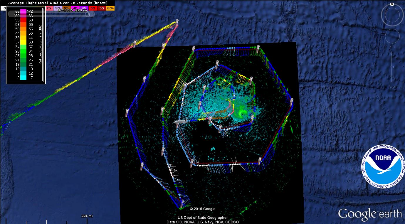
NOAA Hurricane Hunter G-IV upper flight level data through 0015z and P3 radar at 1737z
The evening Gulfstream IV upper air flight gave us some insight into how strong the winds are to the NW of Danny. On their first leg inward they found winds at 42,000 ft/200-150 mb of 20-30 kts(pink and yellow above). This corresponds well with the CIMSS imagery. Danny will begin to feel some of that shear tonight and even moreso tomorrow. These high winds aloft will do two things: assist the outflow channel and eventually take off too many clouds from Danny’s CDO. That first part is already occurring. Upper level divergence has increased this afternoon right over Danny’s core in part due to the higher winds aloft, but also due to Danny’s strengthening. Divergence can be seen in satellite imagery as wispy clouds to the west and an elongation of Danny’s structure to the north and northeast as winds are coming from the southwest. Windsat at 21z showed that the northern CDO is still strong with an open eyewall to the SW similar to what radar had earlier. After 00z, the eye has remained covered, and Danny is likely no longer a category 3 hurricane.

Dry air is the other concern with Danny. As of 00z, it seemed that dry air has not entrained into the mid levels yet, and Danny has set up a boundary of sorts in the form of outflow to the NW and an expanding western side could keep dry air away for now. Humidity will drop some more tonight according to SHIPS, but not much. HWRF suggests another dose of dry air tomorrow afternoon. Danny will look considerably different tomorrow.
The Forecast:
Danny should continue to deteriorate tomorrow morning as shear and dry air work their way in. The added intensification today should not matter in the long run due to Danny’s size of only 60 nm. If Danny stays to character, it should hold its own overnight without much intensification if any like the last previous nights since it is moving into worse atmospheric conditions. Water temperatures are expected to increase tomorrow with heat content climbing considerably by Sunday. This should give Danny a ragged look by tomorrow night and Sunday, but convection should be common and intermittent. If you’re a tropical history person, I’d be thinking Dorian in terms of the pulsating nature of convection. The hurricane models seem to think the end result of Dorian is possible, perhaps with a little more strength.
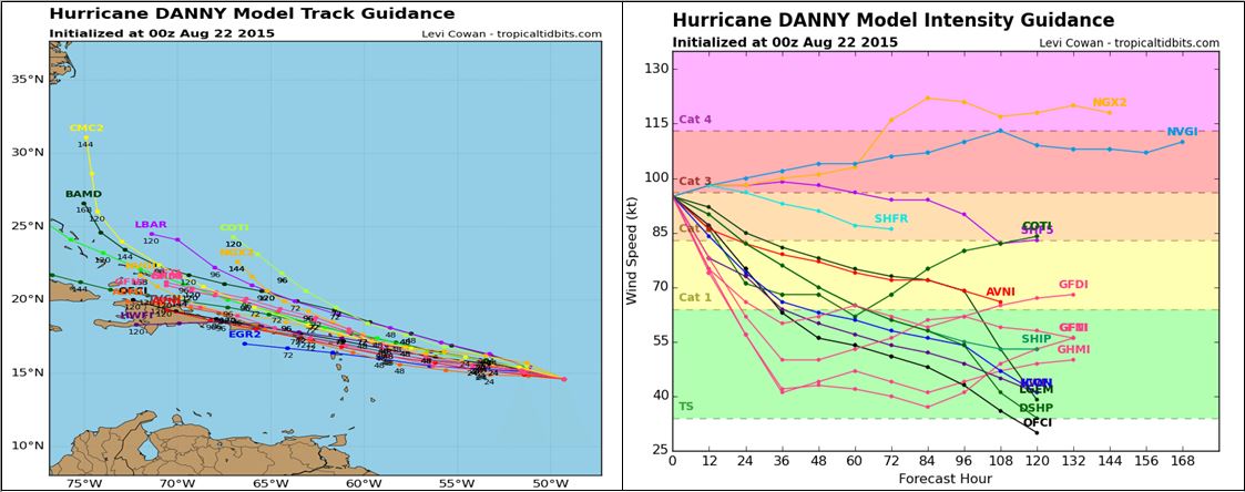
From Tropical Tidbits. (click to enlarge)
The evening model suite, with some of the NOAA hurricane hunter data, condensed the track models a bit. Almost all of the models are north of the Antilles at this point, which means less rainfall for the islands and that it may tap the warmer waters in the southwestern Atlantic. Also to note on the track models is that some of them are picking up on a right turn beyond day 4. NHC remains at the southern edge of the guidance envelope.
Without even bothering with the models that continue to miss the upcoming shear, the general trend over the next three days is for weakening with the exception of perhaps the overnight hours tonight. I cannot ignore the diurnal pulsations that Danny has undergone the last few nights with intensification phases. Danny is likely to either remain steady around the category 2/category 3 demarkation line or weaken just a bit before the roller coaster rides down as Danny crosses the shear. Based on recent satellite trends, choice “B” is the better option of the two. There are a couple of models that completely degenerate this system by Monday or Tuesday somewhere near the Virgin Islands or Puerto Rico. At this point I do not agree with that line of thinking, but I do agree with the NHC that a quick weakening may occur tomorrow. The global models continue to have a hard time seeing/resolving this small system. Shear on the other hand has no problem seeing Danny, and it is likely to take its toll. It is foreseeable that Danny could weaken to a tropical storm by sometime tomorrow night or Sunday morning…well before reaching the Caribbean.
At least three hurricane hunter flights are scheduled for tomorrow. One low level mission from each squadron and a NOAA G-IV upper level mission. More flights are scheduled for Sunday.
Impacts of Danny:
The highest chances of tropical storm force winds are currently in Barbuda/Antigua and in Saint Maarten at around 25-35%. For other locations see below. Tropical storm watches may be needed as soon as sometime tomorrow. Rainfall amounts of 0.5-2″ or 13-51 mm is possible in the northern leewards, but this forecast may change. Higher seas are likely, but only in a very close proximity to Danny’s center. This should be an easy storm for ship traffic to miss. It is currently hard to say which of these hazards will be most impactful as they will depend on the strength of Danny and your exact location. Tune to your local national weather service for a more detailed forecast over the next couple of days.

Probability that Danny may cause winds greater than 40 mph to a certain location
Bermuda Disturbance
Invest 97L is still being given a 40% chance of development through five days, but the official records were not updated from 6z until 00z. Chances are on their way down. Rain is likely on its way for Bermuda as the system moves NW into cooler waters. This non-tropical upper level low to tropical low formation is one of the lesser common corridors for genesis. Interestingly, intensity models bring this up to a moderate tropical storm by Monday. This seems unlikely, and many models have dropped it.
Invest 95E
A tropical wave has caught the eye of the NHC 1200 miles off the coast of the Baja peninsula. The statistical models seem to like it, and the NHC has given it a medium chance of development in the beginning of next week. No impacts to land expected.
Tropical Storm Kilo
Kilo, and less disruptive and dangerous Loke, have been named in the Central Pacific. Although Kilo is currently bare of deep convection, it is expected to intensify over slightly warmer waters. Kilo could impact the western islands by the mid-end of the week next week. CPHC has forecasted a close call for Kauai and Niihau on Wednesday or Thursday with winds in the Category 2 range. Model intensities are almost as spread apart as they are in Danny. With both the Hurricane Hunters and NOAA Hurricane Hunters being spread thousands of miles apart, the C130 will be doing upper level/environmental flights tomorrow morning. The Hurricane Hunters will also start flying into the lower levels of Kilo starting tonight to help assist the models converge to a more accurate solution.
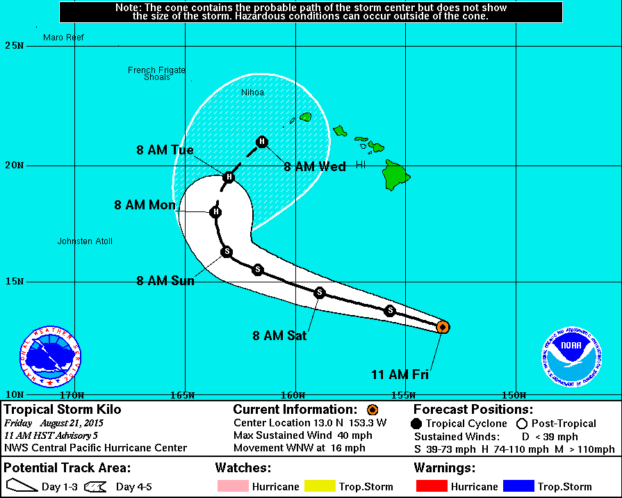
With the active sea traffic in the area, it’s time to start talking impacts. By Sunday, NWS Hawaii has significant wave heights of 5-10 feet near shore and south of the island chain by Sunday with those waves climbing to 12-15 feet closer to Kilo’s center well off shore. Currently chances are about 25-33% of seeing tropical storm force winds on the western most islands. Those chances will likely rise as Kilo gets closer and intensifies over very warm waters. Kilo is not much bigger than Danny with winds above 40 mph only extending out to 70 miles. You may also notice below that there are chances for some stronger winds on the far western atolls (closer to Midway). That is from Tropical Storm Loke closer to the dateline. Those winds would be closest on Tuesday for Midway….an active day for the US territories.

Closing Remarks
The pattern remains active across the northern hemisphere, especially in the basins that the NHC watches. We could have another named storm by the end of next week if the models are correct, but we’ll keep watching.
Stay safe, be prepared, and have a good night. I’ll have comments on the 11pm advisory on twitter.
–Jonathan, @JonathanBelles


You must be logged in to post a comment.