Daily Archives: Thursday, August 2nd, 2012
Florida Forecast Update and TD5 Models
As earlier mentioned, this morning I want to talk about Florida weather since things will be changing over the next few days. The change comes on Friday night or Saturday morning when a tropical wave will be moving through the area. Through Thursday and Friday, drier weather will persist with only 30-40% chances of rain from I-4 south and normal rain chances for the northern part of the state. Friday will be the drier of the two days as sinking air takes over, but as soon as the wave moves into the area those rain chances rank up to 50 to maybe even 60% for the southern half of the state. Rain chances may be as high as 70% for the south Florida metros and the Keys. It will take about 24-36 for the wave to clear the area, but rain chances will remain near 50% going into next week. Effects for the northern part of the state may not be as much noticed as rain chances have remained high all week. High temperatures might actually be a few degrees cooler across the state, but with more humidity in the area dew point will keep feels like temperatures near the same. I will update further tomorrow and on Friday, and I do not expect any development of this tropical wave.
Tropical Depression 5:
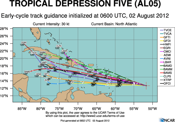
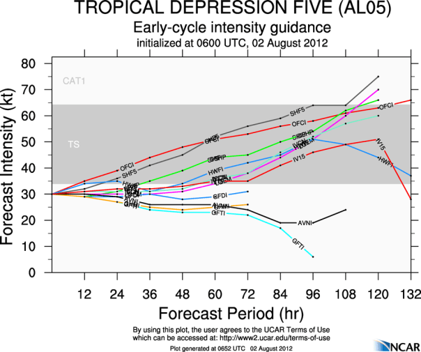
I’m not going to say much this morning, but I did want to include tonight’s early model runs for our new tropical depression as seen below. Note that the NHC (OFCI) is on the high side of the intensity charts:
There were no changes in the 2am update from the National Hurricane Center, however satellite appearance does continue to deteriorate. If current trends continue, we might see a drop in the winds, but I believe that new convection is just hours away. There has been a subtle uptick in activity over the last hour or so.


You must be logged in to post a comment.