Hurricane Sandy Rapidly Intensifies Before Landfall with Cuba. Bahamians Should be Preparing.
As the SHIPS guidance showed yesterday, Sandy rapidly intensified this evening into a strong category one hurricane with winds of 110 mph and a pressure of 952 mb. That’s a drop of 37 millibars in just more than 24 hours. On satellite, shown below, Sandy’s eye cleared out as she passed over Jamaica to the east of Kingston and back into the Caribbean Sea this evening. She is heading toward Santiago de Cuba or just to the west of one of the largest cities in that country. Landfall in Cuba should come within the next hour, likely before 2:00am ET. Evident wear and tear on Sandy’s northern side is noted due to the high terrain on the southeastern end of Cuba.
Hurricane hunters will be doing continuous flights into Sandy once she gets back into the ocean on the Atlantic side, and extra upper air observations through the form of weather balloons have been ordered nation wide to pinpoint a better track for Sandy over the next week. Confidence on the first few days is rather good, but beyond day 3 or 4 confidence is well below normal with options extending from the DelMarVa peninsula to out to sea and missing the continent altogether. Once again, I am going to stick to forecasting the next three days where confidence is the best.
As I said before, Sandy will likely make landfall near or west of Santiago de Cuba over the next few hours, and will likely be inland until after sunrise. Landfall on Cuba could yield winds as high as 115mph. Although pressure falls and some satellite estimates suggest that Sandy could become a major hurricane before landfall. Depending on the exact track that Sandy takes, she may be inland for 6-8 hours. I expect some weakening to occur as well as a reshaping of the structure of Sandy’s inner core and outer flow. I think that Sandy will come off of Cuba’s mainland as a maximal tropical storm or minimal hurricane with winds of 70-80 mph.
From there, an upper level low will pick it up and pull it to the NNW into the northern Bahamas. On Thursday into Friday a set of events will take place that will change Sandy’s appearance and structure once again. Firstly, the upper level low will combine with Sandy, which will further the NNW motion through the Bahamas. Secondly, Sandy will pass over the Gulf Stream, which should limit any weakening that will take place due to an increase in upper level shear. These effects combined will create a hybrid warm core system. Generally when we talk about a hybrid system, we mean there are both cold core and warm core characteristics. In this special hybrid warm core case, Sandy will retain warm core properties at the surface, but the upper level low will expand Sandy’s reach and provide lift support, which will enhance thunderstorm activity. When all of the above occurs, the overall effect will be an expansion in size and a stable wind speed. The latest track models are as shown below:
You’ll notice that kink at the end of the models above. At some point late on Friday or Saturday, Sandy should begin to feel the upper level trough and associated cold front that is coming down from Canada and moving across the US this week. A good deal of uncertainty exists in exactly when this occurs since this isn’t the ordinary cold front that is coming down. I’ll explain more on that over the next day or two as we get closer to that interaction. We’ll have a better idea on how and when the cold front will interact with Sandy tomorrow night when the extra weather balloon data gets mixed into the models along with the recon data from the Atlantic side of Cuba.
Even with the interaction with the cold front occurring on Saturday, I believe that the true transition from a warm core hybrid into a full on post-tropical system may not occur well into next week. A few of the models show a bounce of sorts off of the cold front out into the Atlantic until Sandy hits what is left of Tony and a large blocking high pressure system in the northern Atlantic.
Caribbean/Florida Impact:
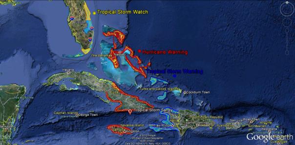
Watches and warnings for Sandy are pictured below:
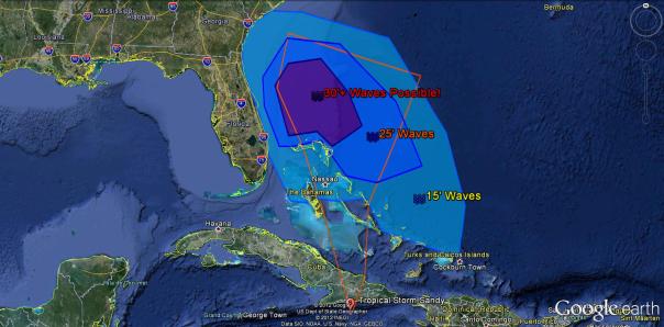
Impacts for the area are outlined graphically below. Not the cone (In orange) by the NHC does NOT limit impacts:
I will update within the next hour or so with the 2am advisory as well as landfall information.
Posted on Thursday, October 25th, 2012, in Florida Weather, Tropical Weather. Bookmark the permalink. Leave a comment.


Leave a comment
Comments 0