Do you know where to HIDE in a hurricane?
If you live away from the water, surge may not be your biggest worry. What might be your biggest worry may blow you away, so tie yourself down and let’s explore today’s topic: Wind.
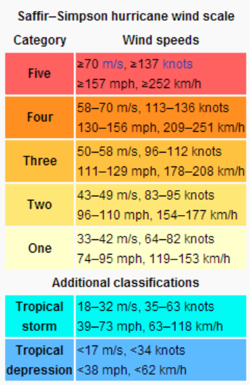
Winds in a hurricane are often categorized by meteorologists using the Saffir-Simpson Hurricane Wind Scale. The SSHWS was devised in the early 1970’s to describe hurricane wind damage to the public. It was mirrored after the well-known Richter Scale, which is used to rate earthquakes around the world. Up until last year, the effects of pressure and surge were included in the scale. Studies over the last decade along with the real life examples of Irene, Ike, and Sandy have shown that wind does not have a direct relationship to surge or pressure. Thus, the National Hurricane Center and the Central Pacific Hurricane Center decided to change the scale to a pure wind scale.
Even though this scale has some good aspects for historical organization and analysis, it is my belief that this scale may decline in use over the next few decades as new science is developed. Craig Fugate has been quoted recently in saying that there is more to the story than the category, and that will have to be stressed this season more than ever. I think the emphasis on the category of the storm will be lessened within the next few years.

It is important to note the forecast track when you are looking at potential impacts. A category 2 that will pass over your location could be much worse than a category 5 that passes to the right of your location. You can see in the graphic above, which shows the forecast for winds in each of four quadrants, that winds vary in radial extent and in intensity by quadrant. In general, the front right quadrant has been shown to be the strongest part of a well developed tropical system. There have been numerous cases where other quadrants were considerably stronger than the front right quadrant. One such case was Hurricane Wilma as it made landfall on the Florida west coast. The winds were strongest in Wilma at that time in the Miami metro, which was well removed from the center and at times lied in the front left quadrant. In the Gustav graphic, there is one flaw . Gustav is moving toward the NW, but the four quadrant model is divided so that it matches north, south, east, and west. In order to be correct the divisions should be aligned with the angle of motion.
In metropolitan and mountainous areas, winds can be as much as 1 to 2 categories higher than the official rating from the NHC. The reasons for this is that as air is pushed around i.e. wind, it comes into contact with the surface. This friction slows the wind down, even on smooth surfaces. As you move away from the surface, friction is reduced and winds often increase. If mountains or buildings are close enough, winds are funneled and wind speeds are increased even further. The degree to which these effects occur depends on the angle of the wind, the height of the observer, and the amount of friction. If you combine the effects of surge and wind, the best place to run and hide is often 3-5 stories above the ground.
Video Summary from the National Hurricane Center: http://youtu.be/-BdlnONw09U
Changes to NHC Products
#1 – Changes in Watches and Warnings: This year, the NHC is updating all of its tropical wind watches and warnings. Most of these changes are directly related to flaws that were discovered during Superstorm Sandy. These changes are due to new classifications outside of the SSHWS that have been developed in recent years. Hurricane watches and warnings can now be issued for areas that may be impacted by winds greater than 73 mph even after the storm has undergone a change in core temperature or has moved outside of the tropical or subtropical latitudes. The same goes for tropical storm watches and warnings. All of these changes are summarized in this week’s Meteorology Mumbo at the top right of this page.
#2 – Changes in Cone Size: As the NHC does each year, the cone of uncertainty will be shrunk again this year. The cone is just that, an estimate of uncertainty based on forecast accuracy over the last 5 years. The cone encloses two-thirds of the error of the last five years. It does NOT enclose all of the impacts that will be seen over the entirety of the storm. It does NOT mean that areas outside of the cone will not see intense winds or surge, and in most cases a majority of the impacts will be outside of the cone at landfall.
Point: What does the cone mean to you? If you are in the cone, it means that you will likely be impacted by high winds, large surge, and heavy rainfall within the next few days. These impacts may last for days after the cone has passed on. If you are in the cone, you should be watching for advisories, watches, and possible warnings from your local officials, and you should finish preparing your storm kits.
Current Weather Note:
The area of disturbed weather in the Gulf of Tehuauntepec has evolved into an intensifying tropical storm. It’s name is Barbara, and it currently has winds of 45 mph. It is forecast to move toward the isthmus of Tehuauntepec over the next 48 hours. A few models bring the essence of Barbara into the Bay of Campeche and bring tropical rainfall toward the Gulf of Mexico in about a week. I’ll keep watch over this during the next week or so.
A Personal Plea
As the Florida rainy season begins, lightning has become an issue. I say has because today a 51 year old woman was struck and killed by lightning just southwest of Clearwater, Florida as a line of storms moved in on the beach. Please, if you hear thunder or even see storms moving your way, MOVE INDOORS. No day at the beach or beer in a boat is worth a lightning strike. Unfortunately tonight, the woman who was stuck was a friend of a friend of mine. I did not know this woman, but I do not want the next fatality to be one of you. Be safe, not sorry! For more on this story go to: http://www.tampabay.com/news/weather/pinellas-deputies-investigating-death-believed-caused-by-lightning-strike/2123520
Share this!

Posted on Tuesday, May 28th, 2013, in Florida Weather, Tropical Weather. Bookmark the permalink. Leave a comment.

Leave a comment
Comments 0