Daily Archives: Thursday, July 25th, 2013
A Day of Ups and Downs in Dorian’s World
Well, it was more like downs, and ups, and downs, and ups again. All of the various factors that tropical cyclones can be affected by were in play today. As Dorian left the area with the coldest waters, all was good, and convection held his intensity at 60 mph. Then, this afternoon the stack of pancakes slid apart as winds at different levels changed. As easterly wind burst from Africa pushed Dorian’s low level center toward the west ahead of the mid level center while entraining a bit of drier air from the Saharan Air Layer at low levels. For a time, I was under the impression that this storm was done, but in a very timely fashion Dorian put on another show. One of the strongest convective bursts happened right over the low level center. As the low level center slid out from under, the anticyclone aloft, which protects systems from shear and dry air, began to decay and slide off. The convective burst was strong enough to realign all of the pancakes in just a couple of hours. In the most recent hours, convection has waned a bit, however it should be enough to allow for this storm to just keep swimming. Below is a clickable satellite loop that appears to show that the layers are a bit dislodged this evening, although thunderstorm activity remains moderate:
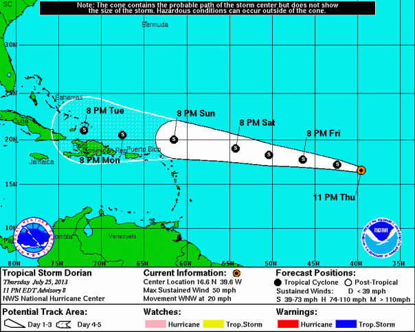
As of 11pm, the official numbers are on the weaker side:
Location: 16.6°N 39.6°W
Moving: WNW at 20 mph
Min pressure: 1001 mb
Max sustained: 50 mph
The official track is as follows:
Notice that this is the first significant change in thinking from the National Hurricane Center since genesis. The track models, although still tightly clustered, have shifted a bit to the south today, and the NHC has followed suit. This shift is fundamentally due to a strengthening Bermuda High in the last half of the forecast period of five days. As much as the intensity of Dorian went up and down today, the case could be very much the same for the next five to seven days. Below are both the spaghetti models and the intensity models. Note that I have removed the climatology models from the track guidance, and I did so because Dorian will likely defy the odds and head on a very unusual westward to west-northwestward path from its current location.
The Favorable Factors for Dorian:
- Heat: Dorian is heading toward higher ocean heat content and warmer sea surface temperatures, which will provide ample energy for the low levels to survive
- Diurnal Max: In the short-term, thunderstorm activity should be aided by the overnight hours. Diurnal Max is the maximum difference between warm sea surface temperatures and cool upper levels in the atmosphere. This difference supplies instability and lift for thunderstorms.
- Brakes: Unlike Chantal, Dorian should slow down in a few days. Dorian is not and will not go nearly as fast as Chantal did.
The Unfavorable Factors:
- Lower Moisture Content: Dorian is leaving the tropics, and an area of convergence that is supplying moisture. The latest SHIPS guidance shows that humidity in the mid levels of the atmosphere will fall below 50%. As we saw this afternoon, the Saharan Air Layer is in play, at least for now, and could send short-term blasts of dust into Dorian’s core.
- Shear: Bottom up shear is a possibility until Dorian leaves the tropics, which could once again push his lower levels out from under him as it did earlier today. Upper level shear becomes more of a concern by early next week. Forecasts for shear have come down in recent days.
In the grand scheme of things, intensity will likely be up and down like day and night until Dorian gets closer to the Lesser Antilles. I have no reason to argue with the NHC thinking, which keeps Dorian at an unsteady 50 mph for a number of days, and then forecasts slow strengthening.
Impact:
- Seas will be the first thing to notice in about 3 days on the northern and eastern shores from Puerto Rico down to Barbados. The initial forecast from TAFB would bring in 4-8 foot waves Sunday into Monday, likely to increase from there. This forecast is intensity dependent.
- Wind: Winds on the islands will begin to increase on Sunday from east (Barbuda) to west (Puerto Rico) later in the week. We’ll talk about this more as a better forecast comes about in the next few days.
- Bottom line: If you are in the northern Leeward Islands, Hispaniola, or the Bahamas, have your hurricane kit ready just in case this steers a bit closer that currently forecast!
Reconnaissance: An early mission has been progged to NOAA for surveillance on late Saturday night, and a low level mission has been progged for Sunday morning. Depending on trends in Dorian, the morning calls with CARCAH could easily change these plans, so stay tuned. The next Plan of the Day for both Hurricane Hunter troops will be out during the late morning hours tomorrow.


You must be logged in to post a comment.