Daily Archives: Wednesday, August 14th, 2013
TD5 forms. Where will Erin form?
Just a short update tonight since much of my thinking is the same as last night. Both systems in the Atlantic have developed, and the east Atlantic system has become Tropical Depression #5. The western Caribbean system seems to be organizing, but it is currently in a downward trend for the time being.
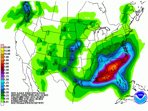
Invest 92L /the Caribbean low pressure system should continue to organize and develop over the next few days. Most of the models are very similar to what they were yesterday. There remain two distinct camps in the track models with one scenario taking 92L to the west as a weak system and the other scenario taking a stronger system to the NW then NNE toward the central Gulf. The associated tropical wave will be the main engine running this system for the majority of the next 24 hours. If 92L can get it’s self going and if it can form into a tropical cyclone by the time it hits the Yucatan Peninsula, the chances are better that the second scenario will play out. If shear remains higher and land interaction becomes a bigger problem, then the first scenario will likely play out. In either case, a lot of rainfall will be strewn from the Yucatan toward the northern Gulf Coast. From New Orleans to Atlanta to Savannah, residents can expect 4-6 inches of rain with locally higher totals. We’ll have to nail down any wind impacts when 92L gets into the gulf since it seems to early to nail down any direct path right now. I do think that 92L will become a tropical cyclone either tomorrow or early on Friday. I believe that TD (discussed below) will become Erin, but the 2nd name down the list is Fernand.
Below are the forecast tracks and the rainfall forecast from the Weather Prediction Center:
Tropical Depression Five has formed this evening in the far east Atlantic. In the very near term, TD5 will produce heavy rains and locally high winds in the southern Cape Verde Islands. TD 5 is under conditions that should allow some slow growth over the next 3 days before TD 5 hits slightly cooler waters, drier air, and a bit more shear. This may be Dorian part two, but the leeward islands may want to watch the path of this system toward the middle to end of next week. This will likely take the next name on the list, which is “Erin” .


You must be logged in to post a comment.