Daily Archives: Sunday, September 1st, 2013
Tropics are becoming active
The Atlantic is heating up as we reach the peak month for activity in the basin. There are currently two invests in the Mean Development Region (MDR) with a low chance of development in the short term. After Fernand made landfall last week, the basin went pretty quiet with the exception of the African wave train. A steep increase in instability, a drop in dry air, and an increasingly favorable MJO should resuscitate the Atlantic over the next week.
The first of two invests (96L) is fresh off the coast of Africa and seems to be undergoing poofogenesis before even making it to the Cape Verde Islands. The current spaghetti models show a general trend toward the northwest with a decent gain in latitude over the next few days. With environmental conditions (dry air, shear) becoming prohibitive for development, the time for this system is quickly running out.
Impact: Expect heavy rainfall in the Cape Verde Islands over the next day or two with higher than normal wave activity.
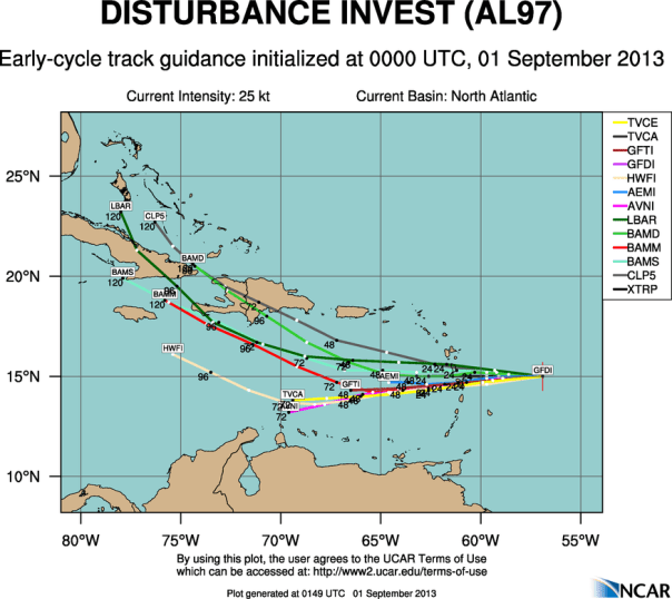
The second of two invests in the Atlantic, Invest 97L, has much more of my interest at the moment. The Hurricane Hunters showed a broad circulation 350 miles east of the lesser antilles last afternoon, and convection has been on the increase since their departure from the system. With dropsonde data in the models, the current thinking is that 97L will trend toward the west through the lesser antilles as a weak disturbance with gaining organization. An Upper Level Low is exhibiting shear in the area of 15-25 knots on the northern side of 97L, which combined with slightly less than favorable mid level moisture should keep 97L weak for the time being. The forecast challenge beyond 48 hours become whether or not the ULL disengages with 97L or not. Currently, I liken the situation to two people running down a pair of lanes toward a finish line of some sort with a tree in the middle which will obstruct both paths. That tree, is of course the island of Hispaniola. In order for any organization to take place, the ULL must either weaken or gain latitude at a faster rate than 97L. After 2 days, 97L will be out of the eastern Caribbean death zone (a climatological anomaly in the basin that prohibits growth), into warmer SST’s and ocean heat content, in slightly more humid atmospheric columns, and should be temporarily far enough from land that chances of development are decent.
Thus far, this has been one of the most climatologically “normal” systems we have tracked. The others being Fernand and Andrea. Climatology would suggest slow development over the next few days, and some of the models show enhanced development after 3 days.
Impact: Expect heavy rainfall in the central lesser antilles over the next 36 hours and enhanced rainfall chances in the Caribbean over the next 5 days. Waves should be in the 6-9 foot range in close proximity to the tropical wave as it passes, with higher waves in the open Atlantic north of the islands. Gusty conditions are possible. This may become a threat to the Greater Antilles and the Bahamas in the days to come…be prepared for tropical weather as we head into the peak of the season. More than half of the season is still ahead of us activity wise.
Special Note: This was the first post created in part using a mobile device. I should able to initiate posts and respond to twitter (@JonathanBelles) with more ease with this new capability. Expect more frequent posts over both medium.


You must be logged in to post a comment.