Signs of Summer: Heat for Now…
Happy Cinco de Mayo everyone!
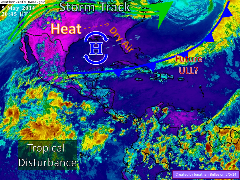
My spring semester has ended at Florida State in good fashion, and that means I have more time to post. Seasons are changing across the southeast, and that means there will be a few rapid changes from unseasonable wet (or drenched as we saw in parts of Florida last week) to scorching hot. For now, high pressure has built in across the southeast pumping in heat from the pacific southwest. Temperatures in Texas and Oklahoma have climbed into the 90s and 100s, shattering records by 5 degrees. Temperatures above the century mark arrived in Oklahoma ahead of schedule by more than a month. In the southern Appalachians, relief has arrived in the form of dry air which has moved in from the Ohio Valley. Temperatures climbed into the 90s in north Florida for the first time since October. Even the 90s are a relief for many Floridians after last week’s record-breaking deluges in Pensacola/Mobile and Tampa Bay.
The high pressure zone that has created much of this heat will slowly move toward the Atlantic and temperatures will once again cool off in the central plains. By Wednesday and Thursday, this heat will be shoved out by a sharp dig of the jet stream into the area. Of course that means severe weather will be a possibility from Wisconsin to north central Texas. This shift in the location of high pressure will also drive humidity northward toward the plains, and eventually toward Florida and Georgia.
For us Floridians, I’ve heard murmurs that summer is here to stay from friends and family. May is generally the driest month of the year, and this week will represent just that…dry and warm. As we move into next week, the weather forecast models (namely the GFS, although Euro meagerly agrees) we could see an upper level feature move closer to the southeastern US from the Bahamas. It is likely that this feature would develop from a decaying frontal boundary in the area. This feature, 5-10 days out, would flirt with a positively tilted trough that may or may not make it to the southeastern US. At the least we would see increased rain chances in south Florida, the Bahamas, and Cuba. I do not think summer has sunk in quite yet in contrast to the word on the street, but we will have more and more signs of the dog days.
What could possibly be more interesting? Well, that giant blob of cloudiness and thunderstorms south of Mexico. It is sitting on water temperatures well above normal for this time of year. Climatologically, that area often becomes the first to ignite with activity as the season begins. The eastern Pacific Hurricane Season begins May 15th, and the season should be an above average one with the incoming El Nino warming waters out there. This early season activity has no bearing on the Atlantic. The likely forward direction is toward the north, then northeast ahead of the next North American cool front. As it moves northward, we can expect more rain and moisture in Mexico and the Rio Grande valley.
Remember, now is always the time prepare for the weather.
Are all of my readers ready for summer?
-Jonathan, @JonathanBelles
Share this!

Posted on Monday, May 5th, 2014, in Florida Weather, Severe Weather, Tropical Weather. Bookmark the permalink. Leave a comment.

Leave a comment
Comments 0