Upper Level Low near Puerto Rico is Showing Life
While Mother’s Day looks calm in the tropics, enough moisture is around to spawn showers across the Gulf Coast tomorrow. Along with the moisture stream on the backside of a dominant high pressure system located to the north of the Bahamas, a dying area of low pressure continues to press into the area. Low to moderate rain chances can be expected from New Orleans to Jacksonville and down the spine of Florida. At the 9pm hour, showers are hanging on east of Tampa and across southern Georgia and Alabama. Another boundary will move into the southeast…possibly one of our last cool fronts in Florida with any oomph…will dictate the motion of an upper level disturbance gaining strength in the Caribbean.
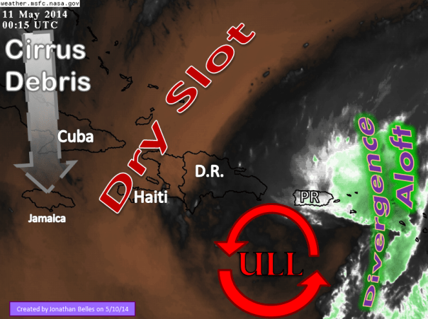
First things first….this is NOT going to be come tropical. It should just be a tropical rain maker for the Greater Antilles. Most of its energy lies in the upper levels, and depending on which imagery you are looking at you might even miss the trouble maker. A local dip in the jet stream near the eastern islands is allowing thunderstorms to build to the east of Puerto Rico and over the USVI through upper level divergence that acts like a vacuum. The jet scoots air away from that area in the upper levels, which creates suction from the lower levels into the upper levels. That creates thunderstorms. And that is what you would see if you looked at radar imagery out of Puerto Rico. You would also see streams of rain coming in from the northeast, and that is caused by the surface trough or area of low pressure that is also slowly moving from west to east.
The jet stream, and the localized sharp upper level trough, are expected to break down within the next 24-48 hours. We should see thunderstorm activity diminish after that. If you look at the graphic below, you can see a lot of dry air that is being dropped on the ULL as we speak, and that will help with the weakening process at the upper levels. You can also see some of the cirrus debris in advance of the southeastern US area of low pressure.
After the upper level parts of this area of low pressure fall apart, we will still have to track to lower levels. We should be able to track to surface trough all the way to the Florida east coast or western Bahamas. This system, not-depending on model, will take a while to move toward the states. The large high pressure system will keep anything weak to the east of it, however a strong trough in the Rockies will push that blocking high out of the way. These two systems, the low pressure system in the Caribbean and the trough will meet up late next week over the Bahamas or southeastern US.
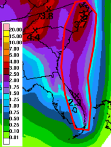
Again, this is not expected to become anything tropical…but if you ask the Constantly Making Cyclones model (CMC), the a stronger storm may develop in the middle of next week. I think that is over doing it, but I do expect rain chances to be kicked up from Florida to the Carolinas before next weekend. Forecast rainfall in inches is shown below. Not all rainfall here is from that system:
As always I’ll be following this system, and a possible system in the southeastern East Pacific by early next week. Have a great Mother’s Day to all of the mothers out there!
Be weather aware!
–Jonathan, @JonathanBelles
Posted on Saturday, May 10th, 2014, in Florida Weather, Tropical Weather. Bookmark the permalink. 1 Comment.


It’s hard to find your blog in google. I found it on 17 spot, you should build quality backlinks , it will
help you to rank to google top 10. I know how to help you, just search
in google – k2 seo tricks
LikeLike