The Atlantic is Clear, But The Tropics are Very Active Out West
The second month of the hurricane season continues to be inactive in the Atlantic, but July is shaping up as a very active month for the western two-thirds of the Pacific. It has been more than two weeks since Tropical Storm Bill crossed the United States. The Atlantic seems to have collected every piece of meteorological calmness it can: high vertical wind shear, basin-wide dry air, and some cooler waters in the development region. There is a large contrast in the Pacific Ocean where three tropical cyclones are already crossing the basin and one disturbance may have some impacts on Hawaii in the next week. I’ll get to that forecast, but first I want to start in the Atlantic.

Atlantic water vapor imagery from July 6th. Expand loop by clicking on satellite image
On the water vapor image above there are a few things to note (in no particular order):
- There are two upper level lows, one north of the Turks and Caicos and the other in the eastern Gulf of Mexico. These are well developed, and they both keep a lid on tropical development. Both ULL are expected to crawl west of west-southwestward over the next few days. Both will slide unfavorable dry and sheared air into the Gulf, Western Atlantic, and Caribbean.
- The jet is anticipated to lay across the Caribbean this week with 100 kt of shear. You can see the effects of a currently much weaker shear just east of the Lesser Antilles, but much stronger high level winds (30-40 kt at 100-200mb) are currently in place. Some divergence is assisting this activity.
- Extended Saharan air layer and otherwise dry air across the basin. This is visible on the loop above in the reddish-brown color. Large plumes of this dry air are coming from Africa and continue to travel across the Atlantic with tropical waves and the ULL. You can see the extent of the dust in the modeled image below. Even the thinner, or blue/light purple, dust can be seen in the skies above the Caribbean and Gulf coasts as a haze.Sunsets and sunrises are likely red in the heartland of the US where this dust is mixing with smoke from fires in Canada. The more thick the dust layer is the more detrimental that layer is to tropical cyclones

Dust across the Atlantic as modeled by NASA for this evening. Provided by WeatherBell
It is pretty obvious that tropical cyclone activity will remain low through at least five days , and probably through 10 days. The NHC agrees with this sentiment. A secondary source for development may be the MCS train that has been traveling toward the east coast through the southeastern US. The waters in the Gulf of Mexico are very warm and supportive for development should atmospheric conditions get more favorable.
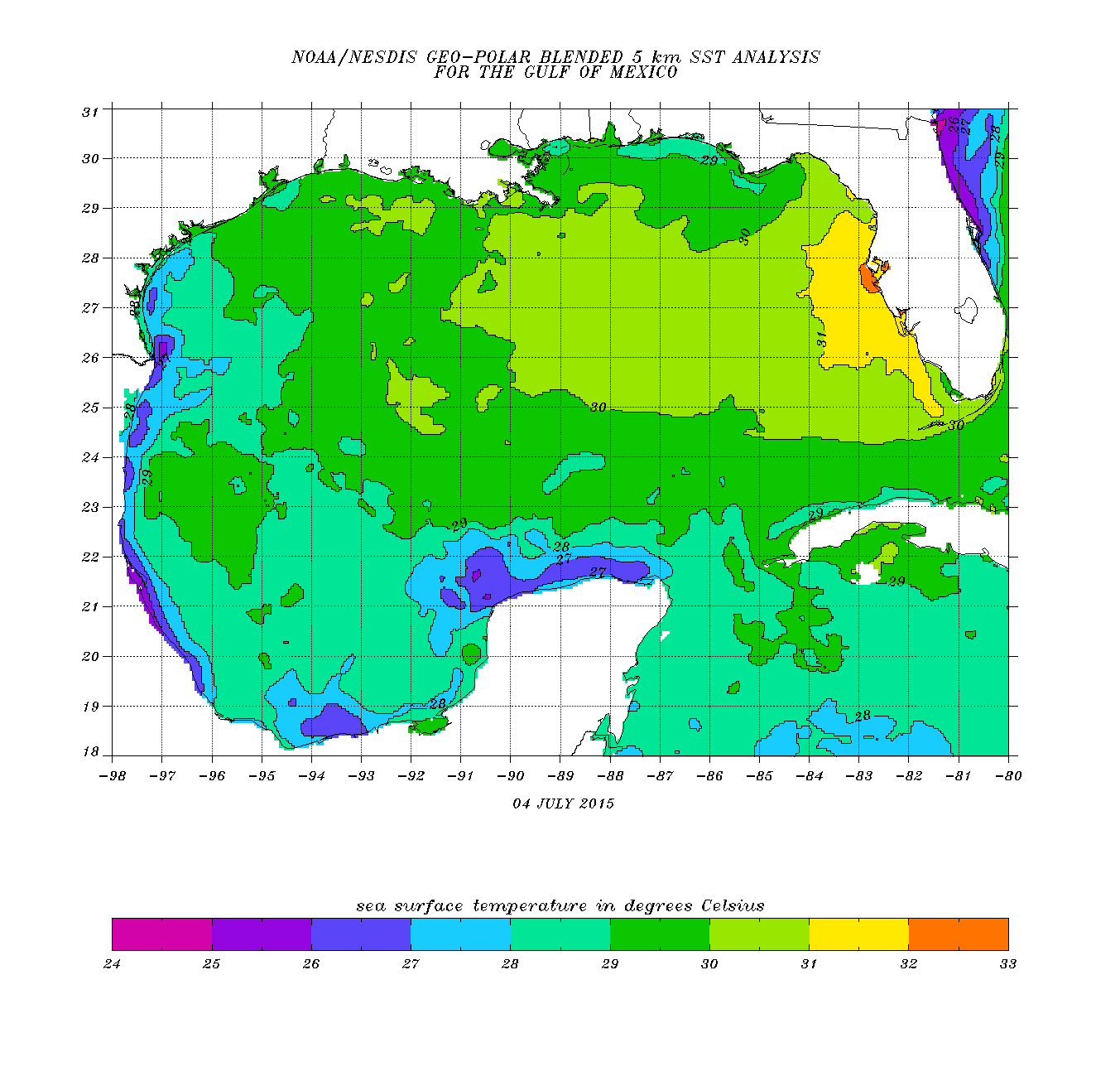
Gulf of Mexico water temperatures in Celsius.
The Active Pacific
Counting below from China eastward there are three tropical cyclones: TS Linfa, Typhoon Chan-Hom, and Typhoon Nangka. All three are forecast or are currently causing troubles from the islands of the western Pacific and/or the Chinese mainland. The typhoons are both expected to intensify as the move west-northwestward. Nangka is expected to cross waters to the north of Guam midweek.

Much farther east, the central pacific hurricane center will likely be busier toward midweek as well. Move two blobs southeast of the Hawaiian chain and you can see an organizing invest 96E. That system currently has a high chance of development. Current forecast models bring this system to the north of the islands toward the end of the week as a minimal tropical storm. Slow development is expected with 96E. The next name on the CPHC name list is “Ela”.
Long Term Signals (and Geek Signals):
Note: If you have no knowledge of atmospheric waves, read this recent blog post by the National Hurricane Center first: https://noaanhc.wordpress.com/2015/06/25/the-ups-and-downs-of-predicting-tropical-cyclone-formation-the-role-of-atmospheric-waves/
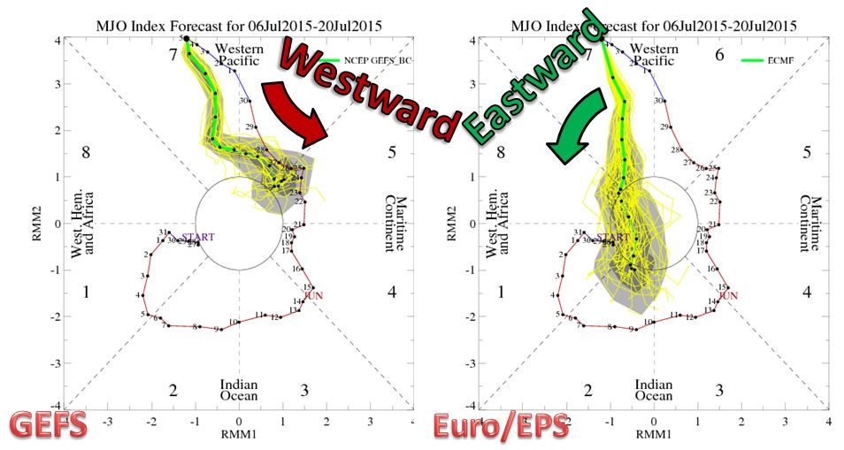
The long term wave signals that climatologist and meteorologists like to use for long term forecasts are very supportive for Pacific activity through this week, but fall flat as the signal is investigated farther east. Below are the Madden-Julian Oscillation from the GFS and Euro Ensembles. Note that the signals are opposite in propagation direction, but the end result is a nearly muted (within the center circle) for favorability in any basin. For the Atlantic we want to see the signal in the left side of the diagram. For Pacific cyclones, we want to see the signal in the upper part of the diagram. Note that the distance from the center of the diagram is a direct representation of the favorability of the MJO signal. Looking at the diagrams, they both show very favorable signals for the western Pacific. We have three tropical cyclones there now. If the GFS is correct, activity will be increased slightly toward Oceania closer to July 20th, but if the Euro ensembles are correct then the eastern Pacific may see a slight increase in activity next week. The Atlantic shouldn’t seek much of any help from this signal.
The Kelvin wave forecast shows a slight increase in activity for the eastern Pacific and western Atlantic basins during the middle of the month. Important: These global waves are only creditable for general trends in tropical activity. The Atlantic will have to moisten and shear will have to lessen before any substantial activity can occur. My current forecast is for no tropical activity through July 15th with a fairly high confidence.
More updates as always on twitter @JonathanBelles,
Stay safe,
–Jonathan
Share this!

Posted on Monday, July 6th, 2015, in Tropical Weather. Bookmark the permalink. Leave a comment.

Leave a comment
Comments 0