Chris begins to weaken and the home brew is turned on high
It’s been a busy late June day in the Tropics. Based on satellite fixes of Chris this morning, he was upgraded to a hurricane. The first hurricane of the season was short lived however, and Chris has since weakened back to a tropical storm. Chris should become a post-tropical cyclone overnight, and poses no threat to any land.
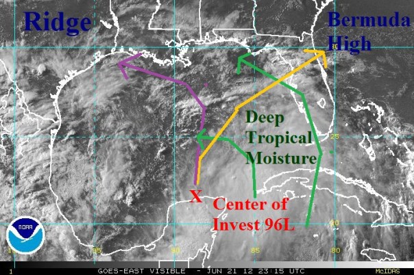
The story is entirely different in the southern Gulf, where newly designated Invest 96L is beginning to show signs of organization just north of the Yucatan Peninsula. During the 8pm TWO (found below and to the right), the NHC gave 96L a 70% chance of becoming a tropical depression over the next day or two.
Most of the storms and thunderstorms continue to be concentrated over the Yucatan channel and southeastern Gulf. Cyclonic flow continues to bring in clouds and rain from the Caribbean and into Cuba and much of Florida. Along with daily heating, this moisture created a rainy day for many south of Orlando and also for anyone on the Yucatan peninsula. More of the same can be expected for Friday and Saturday, although tomorrow morning should be relatively clear of rain until the afternoon rush.
Invest 96L: In Depth
Invest 96L is located at 22N 89W, has a pressure of 1007 mb, and has winds of 25 mph. Thunderstorms continue to be located on the southeastern semicircle closer to the warmer waters of the loop current. The low center is right on the coastline, if not just inland over the Yucatan. Upper level shear is becoming more favorable for 96L, but any northward movement will place it into an area with higher shear. The shear over the entire Gulf should lower over the next day or two as a growing upper level anticyclone grows atop of 96L, and allows for better ventilation. Lower level vorticity seems broken, but moderately strong. Consolidation of this, and a movement away from the Yucatan should allow for slow strengthening into a tropical depression late tomorrow. Hurricane hunters will be enroute to 96L tomorrow afternoon for a better look at the system. Each of the models shows modest strengthening of the system, but that’s where the agreement ends.
In one suite, we have a number of models including the EURO, which makes for a slower northerly movement into the central Gulf. This slower movement, allows it to miss the incoming trough with enough time to be nudged westward by the Bermuda High. In the other suite, there is a single model — the GFS, which takes a sheared mess toward the northern Florida peninsula. Suite one is seen in purple below and suite two is seen in yellow.
In either case, the possibility of a slowdown in the central Gulf, which would lead to large amounts of rain for the entire eastern Gulf Coast, is possible. These models all have a large amount of uncertainty with them until a single low forms and the hurricane hunters get in there tomorrow afternoon.
I’ll be back tomorrow afternoon with a look into the hurricane hunter data and our Florida outlook. Congrats to my 500 followers on 5000 views! Looking forward to double that in the coming months.
Posted on Thursday, June 21st, 2012, in Tropical Weather and tagged Florida, Gulf of Mexico, storms, Weather. Bookmark the permalink. Leave a comment.


Leave a comment
Comments 0