Daily Archives: Monday, September 17th, 2012
Non-Tropical Low Brings Severe Weather, Early Autumn Chill
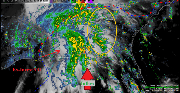
Anyone in the deep south today would tell you it’s been a murky, wet, and in many spots rainy Monday. But, what is causing the rather nasty weather today? All of the above is due to an early season clash of the subtropics and cool air from Canada. A mid-level spin developed yesterday in the far northwestern Gulf of Mexico ahead of a low level trough. The low was designated invest 93L for a short time, and very soon became non-tropical cold-core. This afternoon that same low pressure system has developed frontal features and very ample inflow from the south and east. The low pressure system is pulling in moisture from the Gulf, the Florida peninsula, and the far western Atlantic…in turn spreading storms far and wide across the southern third of the eastern sea board.
Severe weather is just beginning in parts of Florida and Tennessee, but the chance for a few spin up tornadoes and winds greater than 60 mph will increase as the east coast heads into darkness tonight. Outlined above in yellow is the area the Storm Prediction Center has delineated as an area that has a ‘slight risk’ of severe weather overnight. The main threat will be tornadoes after midnight (ET) in areas that it has not rained. Ex-93L will move ENEward into southern MS, southern AL, and western FL overnight pushing this threat slightly eastward. There is also a threat of some localized flooding from Tuscaloosa northeastward to Pittsburgh, where rainfall totals will be on the order of 2-4″. Rain fall totals will be higher in the western Appalachians, and the threat for flooding there is also increased.
All the while, a cold front is slowly trudging its way south and eastward through the upper midwest. The front is currently located from Lake Michigan down toward northern Texas, and is beginning to put together a pre-frontal squall line. This front will likely lock up with ex-93L tomorrow afternoon somewhere in Mississippi or Alabama. During this rendezvous, the severe weather threat will push farther east and north. According to the current SPC day 2 outlook, the threat will exist tomorrow afternoon from Dothan, Alabama to Albany, New York including the east coast.
Florida Impact: I think the chances for severe weather are greater for northern Florida from 8pm to 2am from Pensacola to Panama City, CT) and 5am to 11am (Panama City to Tallahassee, moving west to east, ET). Rainfall will total up to 1-2″ with higher totals in localized strong storms. Winds will be sustained at 10-20 mph or stronger inside localized storms. Rain chances will be 80% or higher for just about everyone west of the Suwanee River.
A look ahead: Starting on Wednesday, cooler drier air from Canada will begin to move into the southeast bringing lower temperatures and lower dew points. This first push of cooler air will mean highs in the 70s and 80s and lows in the 50s and 60s across the southeast.


You must be logged in to post a comment.