Wet Commute Home and a Cool Weekend Ahead
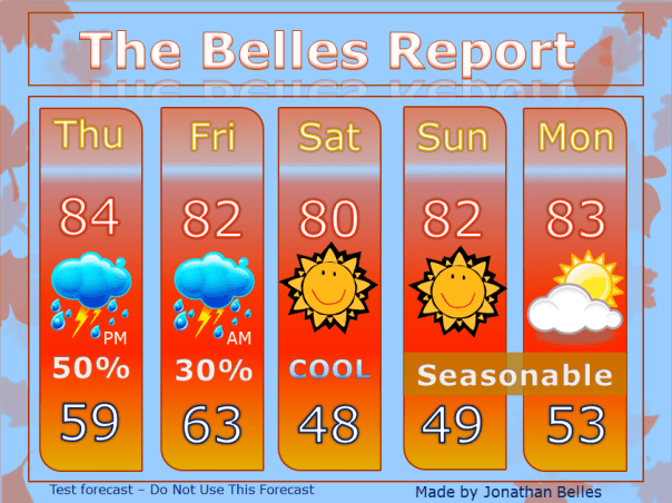
Another batch of cooler air is on its way from the Dakotas. A large low pressure system is moving through the upper mid-west, and is sending cold air deep into the southern tier of the country. Some of this cold air has brought some severe weather from Illinois to Mississippi and Arkansas including four possible tornadoes and a number of wind damage incidents in Missouri and Illinois last night. Fortunately for Florida, most of the energy that caused the severe weather will lift northward with the low pressure system. Contrary to computer models earlier in the week, they are now forecasting a more robust line of storms to move through this evening after 3pm. Your bus stop forecast is all clear for the kiddos on their way to school, but on the way back, it might be a different story. Depending on the exact timing, a few storms may move into western Florida by the time your kids get off the bus and by the time you get out of work. Your commute home could be a wet one from Tallahassee westward. The line of storms will slow down as it makes it into the Big Bend and into northeastern Florida, which is the reason I left rain chances in for Tallahassee Friday. I think a few lingering showers should remain around the eastern FL panhandle until early afternoon on Friday when the front will be forced southward by high pressure to the north. Below is the forecast for the next five days with a cool down just in time for the weekend in Tallahassee.
Posted on Thursday, October 18th, 2012, in Florida Weather. Bookmark the permalink. Leave a comment.


Leave a comment
Comments 0