Moderate Risk of Severe Weather In the Deep South. Severe Storms in Florida Too?
The Storm Prediction Center has just published an update to this morning’s moderate risk outlook for today’s severe weather and recently put out the first ever Christmas Particularly Dangerous Situation tornado watch. The SPC is expecting numerous strong tornadoes and those tornadoes can have a long track. Although I outlined the wind threat in purple below, I believe that the tornado threat will increase throughout the day. The wind threat will continue eastward throughout the day. A wind gust of 72 mph was recently reported at the Jackson, MS airport. Heavy snow is also falling from Oklahoma to Arkansas, and the snow trail will be moving northeastward rather quickly into the midwest and northeast later today. Most of the severe storms are moving rapidly toward the northeast at 55mph.

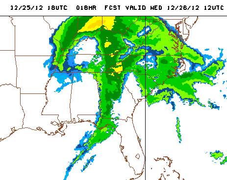
Florida Impacts: Later today, all of this weather will be moving into Florida. A few showers and thunderstorms have already been popping across the Panhandle this afternoon. I expect these thunderstorms to fall apart by 5-7pm ET/4-6pm CT as the warm front pulls away, which will allow for more instability that the main squall line can feed off of tonight. The squall line will reach Pensacola shortly after midnight according to the GFS and NAM, and push eastward toward I-75 by 8am ET. Below I have included the 12z (7/6a CT) 12/26 simulated reflectivity frame of today’s 18z NAM, which places the front near Tallahassee around 7am.
The Storm Prediction Center has placed all of the Florida Panhandle and the rest of north Florida north of I-4 in a slight risk of severe weather tomorrow morning. I think the main threat in central Florida will be high winds and an isolated landfalling waterspout.
I’ll be updating throughout the day on twitter @JonathanBelles. Stay Safe and Merry Christmas!
Edit (3:45ET): A tornado watch has been issued for the western Panhandle from Calhoun and Jackson county westward to Escambia County until 10pm CT. There is a likelihood of tornadoes through this afternoon and evening!
Share this!

Posted on Tuesday, December 25th, 2012, in Florida Weather, Severe Weather. Bookmark the permalink. Leave a comment.

Leave a comment
Comments 0