Severe Weather Risk on Wednesday. How much of a Risk?
Spring seems to have wanted an early appearance in the Southeast this week, but Jack Frost is nipping that in the butt real quick. The battle is beginning in the central plains, where lower pressures are beginning to wind up. This main low will travel toward the NE and take most of the energy toward the north, but the cold front that will trail behind will surge its way into north Florida on Wednesday afternoon with some potentially severe thunderstorms. Some ingredients that will be coming together in this situation include: a strong low-level jet, mild amounts of shear, and large scale upper level lift. It will be mainly a straight line wind event for everyone except the western portions of the panhandle. I think a quick spin up tornado is not out of the question for the western panhandle and much of the deep south. Most of the tornado risk will be taken to the north during the night on Tuesday night.
Timing:
- Western Panhandle: 10a-2pm Wednesday
- Central Panhandle: 12p-6pm
- Eastern Panhandle/NE FL/Tampa Bay: 5p Wed -3am Thu
No strong weather is expected at this time elsewhere in the state. The line should begin breaking apart as it reaches I-75, but should bring rain to just about everyone.
Impact:
- With ample moisture moving into the panhandle on Tuesday, fog could become problematic along the coastline Tuesday and Wednesday mornings
- Strong to severe storms with winds greater than 50 mph are possible during the windows above
- A quick spin up tornado is possible especially in the western panhandle
- Rainfall: up to 1/2″ for the western panhandle, up to 1/4″ in the rest of the panhandle, ~1/10th of an inch elsewhere. No Flooding is expected, but rainfall totals may be much higher in localized areas
- Seas will become choppy by Wednesday morning, climbing to 5-7 feet by mid-day Wednesday in the northern Gulf. Winds will switch from south to north during the day on Wednesday with velocities between 20-25 kts in clear air; higher in storms
- Cooler temperatures will filter into the area by Friday morning with lows in the 20s and 30s in the northern half of the state
I’ll have more on the risk for severe weather, which will likely remain at a slight level via the Storm Prediction Center, for the FL panhandle later today.
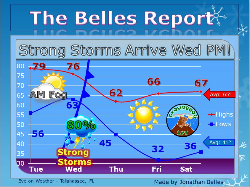
Here is a five-day forecast for Tallahassee:
Share this!

Posted on Tuesday, January 29th, 2013, in Florida Weather, Severe Weather. Bookmark the permalink. Leave a comment.

Leave a comment
Comments 0