Wet Pattern Continues. How Much Did Florida Get in June? Will the Tropics Flood Florida?
The first month of hurricane season is now over, but Florida saw the impacts from one of those two tropical systems. Andrea probably put totals over the top for record monthly rainfall, but the consistent troughing pattern hasn’t helped much either. Take a look at the graphic below. Some spots got more than 20 inches of rain in June, which would amount to more than 200% of normal! The forecast only calls for another wet couple of days.

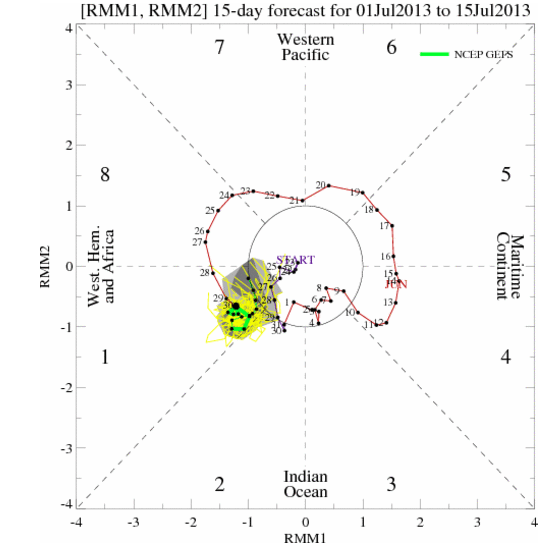
The reason for all of the rain? An upper level low has set up shop in the Gulf of Mexico off the west coast of Florida. Chances are that this “screaming eagle” pattern will not be anything more than a menace for Florida, but the tropics should not stay quiet for long. For more on the screaming eagle pattern, see this weeks Meteorology Mumbo. The global pattern is marginally favorable for tropical development in the near tropics, and even more so in the eastern Pacific basin. Below is a graphic from the Climate Prediction Center of ensemble members of the GFS model that shows where the most favorable vertical motions (wet MJO) are taking place around the globe. You can find Florida near the first/second phase line and the Atlantic falls into phase two. Fortunately for the Atlantic, this pulse of the MJO looks to die before making it entirely into the Atlantic. The green line below depicts the mean of the 20 ensemble members that go into the GFS.
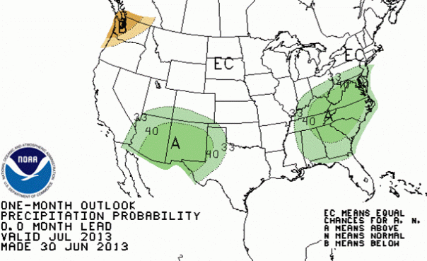
Back here at home, the latest one-month outlook suggests that the chances are better for an above normal month for rainfall on the east coast. Fortunately, rainfall looks to be above normal in the southwest US as well, so there is hope that the wildfires out there will become controlled. My condolences certainly go out to the family and friends of the 19 Hotshots that were killed in action last weekend fighting fires in Arizona.
Tropical Outlook:
Above normal rainfall in Florida early in the season generally means lets hits to the state later in the season, however this is not a rule. I expect 2-4 tropical cyclones during the month of July, with 0-2 of those becoming a hurricane. The long-term models show ‘something’ coming westward into the Bahamas in a week or so that may need to be watching. Nothing threatening at this point.
The Next Week in Florida:
The area of low pressure located west of Florida should drift toward the west over the next couple of days. That will take most of the heavier rainfall and wash out rains to the west. Unfortunately, that will stall a few Independence Day plans for the northern gulf coast including the western Florida panhandle. As always, you can never rule out a few natural fireworks in July, but for most showers should be winding down by the 4th. By the end of the week, the pattern will switch to an easterly flow, which will mean late day storms on the west coast.
Share this!

Posted on Monday, July 1st, 2013, in Florida Weather, Tropical Weather. Bookmark the permalink. Leave a comment.

Leave a comment
Comments 0