97L: Caribbean Cruiser or Hispaniola Hurricane?
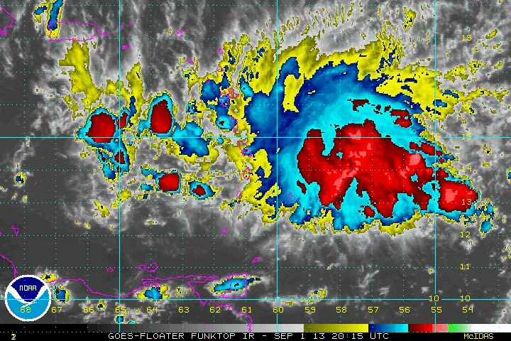
A few interesting things happened today with Invest 97L as 96L fell apart. As I mentioned last night, we would have to see the ULL pull away from 97L in order for any development to occur, and that in fact…sort of happened. I put it in that context because we saw the ULL split into two areas, one that is falling apart north of Puerto Rico and another more robust area near Hispaniola. The two areas have allowed upwelling to occur on the northern side of 97L, which is a good thing.
Generally when someone talks about upwelling, it is often in an oceanic context where something atmospheric feeds off of the surface layer of the ocean and drains it of heat. In the atmospheric context, as used here, two areas of low pressure ventilate the area of low pressure in the lower levels of the atmosphere. Here, we have a couple upper level lows whisking away mass and heat from the “center” of 97L at the mid and upper levels. This is a case where shear is favorable over a tropical system.
This evening, that effect seemed to wear out as convection near the center of 97L has waned since early evening. The “center” of 97L is north of Barbados, and continues to move generally toward the west. Earlier today, the island of Barbados had a semi-reliable westerly wind, which to me signifies that 97L took a run at trying to become a tropical depression earlier today before thunderstorm activity fell apart. 97L has winds of 30-35 mph and a pressure of 1008 mb. Most thunderstorm activity tonight is well to the east of the center of 97L.
Forecast Track:
The track of this system in the long term will nearly entirely depend on the intensity of the system. Currently, the system is being guided toward the west at the surface by the subtropical ridge, which is aligned east to west from the Bahamas eastward. There is a trough in the picture, but I believe this will be a case where the train will miss the station for the most part. The models are in two camps right now with a splitting tropical wave or a more centralized spin in the Caribbean.
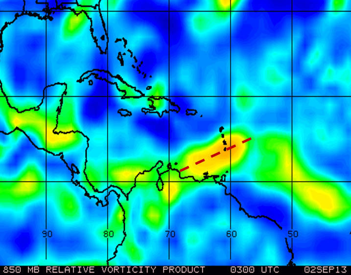
Scenario #1: GFS/Euro solution: As the tropical wave reaches Puerto Rico, it produces two areas of spin (or vorticity) north and south of that island. What I think will actually happen with the second piece of energy is that it comes from a wave following 97L. This will likely take a weakness that may or may not be present north the NW. This solution takes 97L toward the west as a struggling mess, and eventually makes landfall in central America. I am much more inclined to take scenario #2:
Scenario #2: UKMET: This scenario keeps a stronger subtropical ridge and a more centralized vorticity toward the WNW over the next few days. This more centralized vorticity will form in about 24-48 hours in the central Caribbean. I believe that some of the hurricane a barotropic models are taking this scenario a little too quickly. For instance, the GFDL spins up this circulation, which currently is stretched out (Below), within 24 hours and quickly intensifies it before moving into Hispaniola.
Intensity Forecast:
Even though it is now September, I am not buying the rapid intensification story that numerous models are trying to sell. The truth is that this storm is elongated, and it will take a night or two for this system to centralize and develop. Only once it does that, can it tap the better than all season conditions. Note that I did not say favorable conditions. In 4-5 days we will see more favorable conditions, but in the short term there will be 15-25 kt shear around this system and a bit of dry air to work out. If this system is to get a name, it will be in 3-5 day or beyond.
My Forecast:
This system struggles over the next 24-48 hours before showing signs of organization in the central Caribbean. 97L will keep a WNW heading until roughly 75W when it should be in the rough proximity of Jamaica as a developing system.
Impact:
Scattered moderate thunderstorms to isolated strong thunderstorms will move through the central and lower lesser antilles overnight into tomorrow night. Gusty winds are probable. Seas will be choppy at times, especially in the passes between islands as the system passes through. Any localized torrential rainfall may lead to mudslides in mountainous areas of the Caribbean over the next 5 days. Stay prepared!
Climatology Note:
As we start September, we inch closer to the peak of the Atlantic Hurricane Season. During the first 10 days of the season, most storms form in the Gulf of Mexico or the Mean Development Region, which stretches from the Lesser Antilles to the coast of Africa. Hurricanes form this time of year more than any other time of year because water temperatures are the warmest and winds in the layer of the atmosphere where clouds reach their peak heights are the weakest. 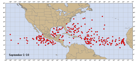
Share this!

Posted on Monday, September 2nd, 2013, in Tropical Weather. Bookmark the permalink. Leave a comment.

Leave a comment
Comments 0