Daily Archives: Thursday, August 7th, 2014
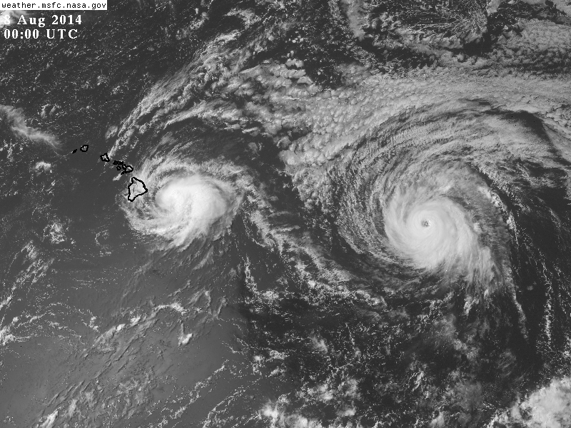
Iselle is Bearing Down On the Big Island While Julio Becomes Annular
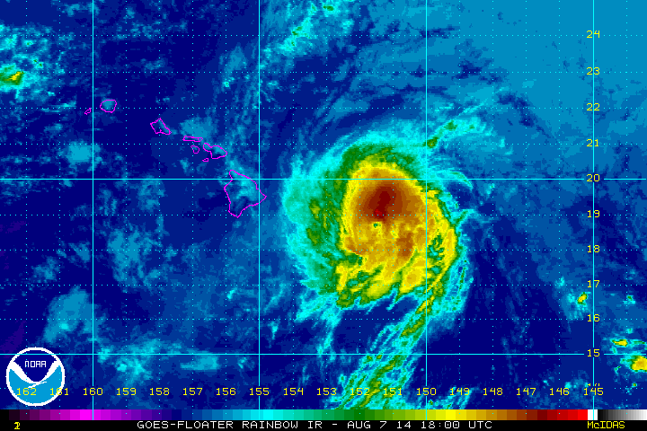
Hurricane Iselle is slowly moving toward the eastern shores of the Big Island in Hawaii. Iselle is now within radar range, but satellite loops and recon continue to tell the real tale of this hurricane. Radars seem to be going in and out as they get battered by heavy rain and near tropical storm force winds. Early during the afternoon (HST) a new burst of convection ignited over the northwestern semicircle, and soon after the hurricane hunters found hurricane force winds. Pressures during the last eye pass seemed to indicate subtle intensification, and the CPHC followed with a minor uptick in the winds to 80 mph. That burst of thunderstorm activity remains sustained however organization is wilting so the CPHC has lowered the winds again. This post will focus on Hurricane Iselle, but a look at Julio will be taken.
Current Official Information on Iselle (as of 5pm HST)
- Winds: 75 mph
- Present movement: Just North of Due West at 15 MPH
- Minimum central pressure: 991 mb
- Hurricane Warning (the first in 21 years in HI!): Hawaii County…winds of 75 mph or greater are EXPECTED tonight into tomorrow!
- Tropical Storm Warning: Maui County, Oahu, and Kauai County…winds of 40 mph or greater are EXPECTED within the next 36 hours!
Impacts:
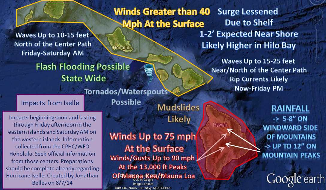
Please see more detailed impacts on the Big Islands in the previous blog post. Some of the wind/wave forecasts have been lessened, but otherwise information is good. We’ll talk about Julio impacts in a couple of days.
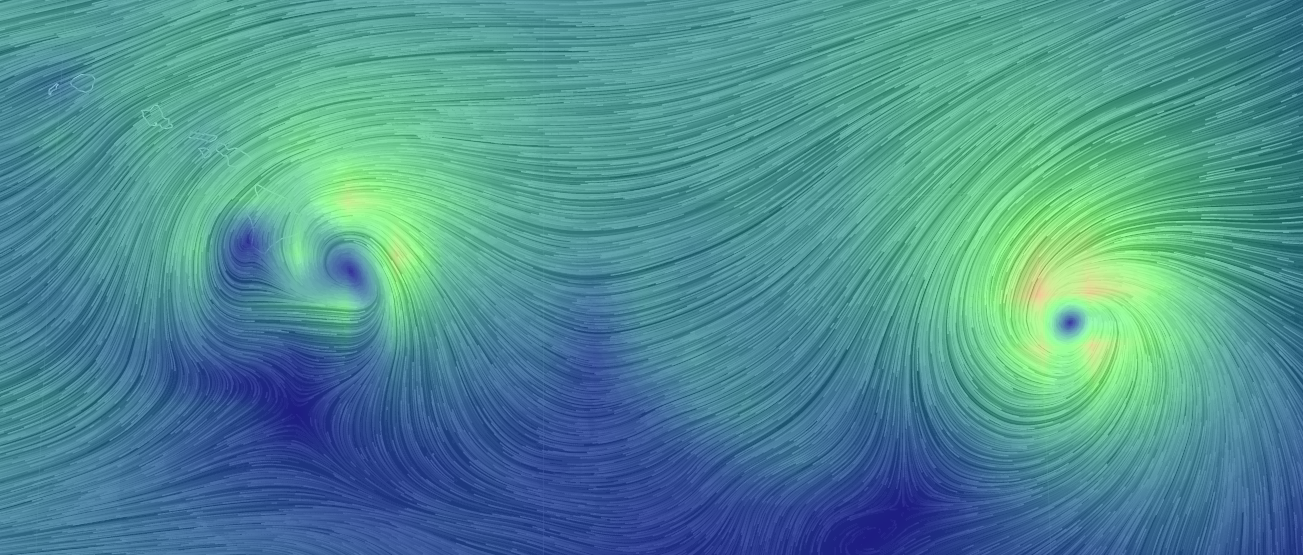
The track of this hurricane could become very erratic during the next 6-12 hours as it navigates the volcanoes of the big islands. Hurricanes and tropical storms tend to bounce off of higher terrain, just like we see with Hispaniola. The mountains are taller, and may have more of an impact on path. You can already see the disruption in winds at the surface below. Winds are being channeled and accelerated through the Maui Channel.
These impacts will generally move from east to west. Impacts will be lesser on the western islands, however tropical storm force winds are still anticipated. Below are the current expected tropical storm force wind speeds from the NHC/CPHC. One thing this graphic does not show is the wind direction.
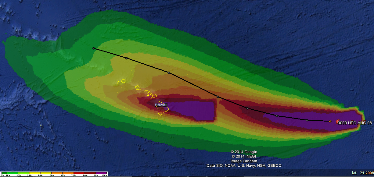
I absolutely hate to put a center line forecast on a graphic, however in this case it comes with an important story. Please note that the windward side of the Hawaiian islands will be different in Julio than it will be in Iselle. In Iselle, the windward (rainy) side of the islands is the north and eastern side of the islands. In Julio, as the center of that hurricane passes, the windward (rainy) side of the islands will be on the western and possibly southern side of the islands. This may catch people off guard if it comes to fruition. Obviously, if the track of Julio moves, that effect may change.
Summary of Hurricane Julio:
- Winds: 115 mph (now a major hurricane)
- Present movement: West at 16 MPH
- Minimum central pressure: 966 mb
- Tropical Storm Watches: none yet
Julio seems to be taking a similar intensity track as Iselle did. The center has really taken shape and shockingly the hurricane may be transitioning into the 2nd Annular Hurricane in a row, which is extremely rare. This CPAC hurricane season is one for the record books. As we saw with Iselle, the intensity of Julio will likely hold steady for the next 24 hours despite cooler waters, marginal atmospheric conditions, and eventually strengthening shear. Julio is likely going to be a hurricane for the next 3-4 days, possibly reaching 155°W as a hurricane well north of the Big Islands. It seems like history is repeating, but thankfully Julio should track well to the north of where Iselle tracked. Models may jog just a bit as new upper level recon data will be worked in to the 00z models. The subtropical ridge should build in by the middle of next week, so Julio will turn west, but only after it passes most of the islands.
As the sun sets tonight on the islands, I hope that if you are reading this from the islands you are taking precautions and shelter from these systems. If it is safe for you to do so, please send me pictures of this hurricane and/or its damage to @JonathanBelles
I have been having some internet issues at home this evening, but I will continue to tweet as I can tonight.
Mahalo for reading, and join me in this conversation on twitter.
–Jonathan


You must be logged in to post a comment.