Daily Archives: Monday, August 11th, 2014
A Trip to the Dentist’s Chair: The Seasonal Forecast
With 94L just a few clouds away from being taken over by our friend SAL and Julio spinning away as a minimal hurricane well north of Hawaii, I thought I would take a look at the rest of the hurricane season and the hurricane season outlook from NOAA a couple of days ago. Most of the below are my opinions only.
Remember, it only takes one.

Again, it only takes one. I want to repeat myself as I will probably do over the next few months to emphasize that these forecasts are really only an idea of the number of tropical cyclones we may see this year in the waters between Portugal and Mexico. They do not tell us where or when they will hit. They also do not tell us the quality of the storms we will get.
If one were to forecast the number of dentists we will see in our lives for non-clean up visits, one might say there is a good chance of 7-12 of these visits. That does not tell us how bad those visits will be, nor will they tell how much those visits will cost or how many teeth we will lose in the end.
We’ve already had two visits to the dentist already this year, and we still do not know how much those trips will cost. We also had a call from the receptionist trying to schedule an appointment. We’ve had two hurricanes and a tropical depression in the first two months of the season or so. Both hurricanes were impactful in multiple countries around the basin. Those two hurricanes do not have much impact on the rest of the season.
I am not a huge fan of these seasonal forecasts since they trend people toward those numbers. I am much more favorable of the right side of the graphic above since it tends people toward possibilities without locking down a number. A similar system is used by the CPC in their climate prediction for 6 days-3 months.
Observations Thus Far:
As we have noted with TD2, Bertha, and now AL94, dry air in the Mean Development Region is high. Dry air in the MDR limits a great chunk of seasonal activity. Throughout the months on August and September – the peak of the season – much of the activity and the reason for the peak comes from Africa in the form of tropical waves. We usually see waves that glide out into Atlantic in July and August to clear this Saharan Dust and drier air, but so far systems have struggled in that area. This drier air is due to a drier than normal Saharan wet season.
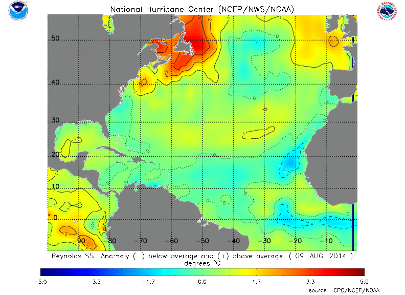
We have also seen cooler than normal waters in the northern MDR and off the coast of Africa, which also limits development there. Water temperatures are generally warmer in the homebrew regions of the Gulf of Mexico and the east coast of the US. Although the graphic below shows cooler waters off the SE coast, waters there are supportive for tropical systems.
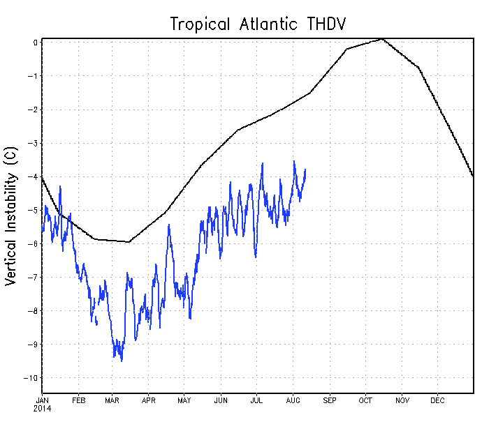
Pending the development of El Niño this fall, wind shear and atmospheric stability are expected to increase. Both of these things limit tropical cyclogenesis. Atmospheric instability is generally below normal in the tropical Atlantic, and has been all year. The east coast and subtropical Atlantic have been most supportive in terms of instability. Shear is the least as of late in the Gulf of Mexico and western Caribbean.
The overall pattern has been for east coast troughing. This scares me a bit for this fall since troughs tend to kick systems from the Caribbean and Gulf of Mexico northeastward. That spells a bad pattern for Florida, Cuba, and possibly the Yucatan if storms can form west of there. If you like cooler weather, you may like this winter if this pattern holds. Again, when and where isn’t part of the NOAA forecast but this has been a persistent pattern that has to be noted. It has limited Arthur to the sounds of North Carolina and kept Bertha off shore.
The Bottom Line:
Prepare for that one system that may come your way. According to NOAA, we’ve got another 5-10 systems coming into the Atlantic by the end of the season and as always the time is now to prepare. It’s as easy as spending 5 minutes and 5 dollars once every week or two to get yourself prepared. Get an extra gallon of water at your next trip to the supermarket or think about your evacuation plan. As we saw in Hawaii, that one storm arrived this week and people were not prepared until a week out…and cases of water shot up $20 or more. Don’t let that happen to you! Don’t make the dentist call you in for a visit. It may cost you a tooth or some dough.
Thanks for reading!
–Jonathan, @JonathanBelles


You must be logged in to post a comment.