Daily Archives: Saturday, June 13th, 2015
New Tropical Disturbance Brings More Flooding Concerns to Texas and Louisiana
Rain. More Rain. Words that folks in Oklahoma, Texas, and Louisiana probably do not want to hear. These are also words that are in forecasts for those three states. Add in one more phrase: tropical cyclone. That may also be in the forecast over the next 5 days. We’ll get to that last phrase in a bit, but the main story for now is the first phrase.
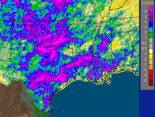
Rainfall over the last 30 days. Areas in bright purple are areas that saw at least 8″ of rainfall in that period. Courtesy of the NWS.
In the last month or so, rainfall has brought up rivers in four states that remain in or near flood stage. At the end of May, the cities of Houston, Austin, and Oklahoma City all had flooding rains. Parts of the Houston metro had 10″ or more. At the time this had a silver lining: drought buster. The drought monitor released on Thursday shows that all but >1% of Texas has been relieved of drought. All of that water had to go somewhere, and it takes time for that water to go anywhere in most rivers. If you look below, the Trinity and Red Rivers, in Texas and Louisiana respectively, have gauges in major flood stage…mainly from last month’s rain. Rivers emptying into the Corpus Christi metro aren’t doing so hot either. June has so far been a fairly dry month for these regions.
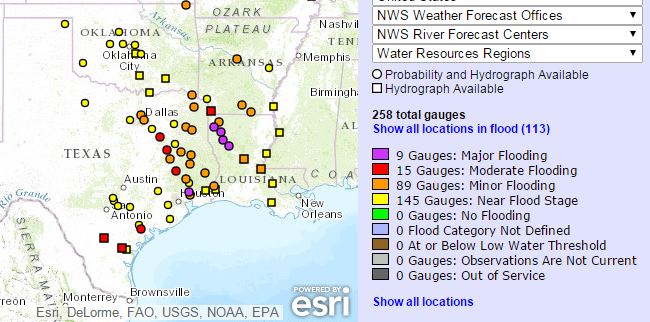
Map showing all rivers that are at least near flood stage in Texas, Louisiana, and Oklahoma. River gauges not in flood stage were removed. Courtesy of the NWS.
Computer models recently have shown an area of low pressure developing at the base of an upper level trough that continues to sit in the Gulf of Mexico. Last night, upper level vorticity was strong in this area, and divergence continues to enhance thunderstorm activity over the Florida Straights and western Caribbean. Low/mid-level spin has developed in the last 24 hours around Chetumal Bay and the southern Yucatan peninsula. The formation mechanism for this system, top-down from an upper level system, isn’t the most common but in this case seems to be very effective. Wind shear of 20-30 knots continues to take cloud tops off to the east. If you’re in central or southern Florida, you are likely seeing the outer fringes of this system, Invest 91L.
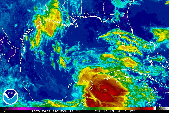
This system is already dropping plentiful rainfall in the eastern Yucatan. Visible and infrared imagery show that this system is not well vertically stacked as you would expect from a sheared system. The same mid-level ridge that has kept Florida under southeasterly flow and has kept the southeastern US warmer than average will assist this system toward the NW at a pretty good clip. This is the silver lining to this story. Current GFS ensembles and spaghetti plots place the center (and probably the least important part of this system) on the Texas coast sometime on Tuesday. There is a moderate level of uncertainty in this forecast mainly due to two features. A) With this disturbance so disorganized and so close to land, relocations of any centers that do form are likely…possibly 50-100 miles in either direction. B) The mid-level ridge will need to be sampled for growth or decay. Right now the forecast is for this system to reach a weakness between that ridge and another area of high pressure over the southwestern US. It is where that weakness sets up that this system will come ashore. A stronger eastern ridge means a landfall closer to Corpus Christi or Brownsville. A weaker ridge will mean a landfall closer to the Louisiana border. A third variable that may come into play is faster intensification if this system can organize, but this is not forecast by any model.
Impact:

Courtesy WPC and TWO. Current location noted by the “i“
The exact landfall point will not be main story for this system. Again, it will be rainfall. Most systems, tropical or not, have characteristics akin to personalities in humans. This system will be more so wet than windy or surge intensive…at least with the current forecast. In the graphic above, the WPC has placed a 5″ bullseye over the Houston/Galveston metro with amounts to 6+” in the center. If any intensification occurs, these amounts could be substantially higher. Amounts of nearly double that are possible locally especially if this system moves slower than currently forecast. I believe that there is a fairly decent chance that these forecast totals will increase. The forecast is for at least two days for precipitable water of more than 2″. Higher rainfall totals should occur on the eastern semicircle from the point of landfall as long as extensive development does not occur.
From the NHC perspective, they have given this system a 50-60% chance of tropical cyclone development within 2-5 days. Winds are already 30 kts/35 mph and are expected to increase slightly. It will likely be 18-24 hours before substantial organization can begin to occur due to land.
The Road Ahead:
The Air Force Hurricane Hunters will be busy over the next couple of days. The first flight for this system may take off late tomorrow morning with sights set on 91L during the afternoon. With development of a tropical system would come reconnaissance every six hours starting on Monday. This will be rainmaker and possibly a flood maker as well. The current forecast is for a weak and eastward lopsided tropical storm somewhere on the Texas coast on Tuesday. We can only expect current flooding to be elevated on some rivers by this fast moving system.
As usually, I’ll be watching and updating on twitter @JonathanBelles
Go Lightning, and here’s to hoping Bish stays in his net tonight. Stay safe everyone!
–Jonathan


You must be logged in to post a comment.