Tropical Squeeze
The clouds have come in, and the storms have begun…but it’s about to get a whole lot more wet.
To start this story, we are looking toward north Florida where a Severe Thunderstorm Watch is in place until 9pm eastern along I-10 from Jacksonville to DeFuniak Springs. The main threats through mid-evening are marginally severe hail and high winds. All of the reports thus far of severe weather have occurred in Georgia, but the risk continues in Florida and will be on the increase as afternoon heating ramps up. Cloud cover may limit storm activity along the gulf coast, but the possibility of high winds continues. If you get any pictures of severe weather, send it to me here and I’ll host it. For more info on the SVR Watch, go to: http://www.spc.noaa.gov/products/watch/ww0358.html
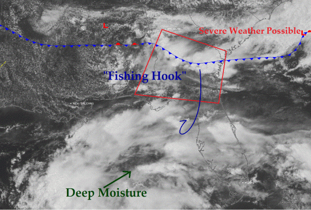
Below I have included a recent satellite image with frontal positions overlayed. I have pointed out a mass of semi-convective clouds that continue to move in from the Gulf of Mexico, which will be pulled in ahead of the cold front like a fish on a master fishing pole starting tonight. The setup is similar in nature to what we had last week, however this front will not be making it through Florida. Central Florida is already moisture laden, but there is no push coming in from the north to push this front through, which could result in flooding by Thursday into Friday.
The fire hose will be turned on later tonight, and will only amp up in intensity through Thursday. Rain chances from Live Oak to West Palm Beach are 60% for tomorrow and upwards of 80% on Thursday. The best rain chances are along the west coast from Levy county down to Collier county where the feed will be the best. Rain chances along I-10 will largely depend on how far south the cold front makes it. The highest rainfall totals will be along and just south of where the cold front stalls out on Thursday and Friday. The hail and high wind threat should wind down overnight tonight, and without the self destructive sunshine needed for storms the severe weather outlook should be on the low side throughout the week.
Impacts:
Very Heavy Rainfall:
This tropical squeeze will create a funneling effect across central Florida through Friday afternoon. This will lead to widespread 2-4″ rainfall totals with isolated amounts up to 8″. At first I was reluctant to include the 8″ possibility, but as the afternoon models came in a few of them came back with nearly a day with over 2″ precipitable water totals and large areas of 3″ plus rainfall totals. I have put these amounts in graphically below:
Rip Current Risk:
With a consistent west to southwest wind, there is a moderate rip current risk from Indian Rocks Beach down to Naples through Friday. Rip currents will carry you out to sea if you are not aware of how to mitigate the risk. First, this week is not a good week to go to the beach, and it is certainly not a good idea to go into the water. And secondly, if you do have to go into the water, learn how to swim out of a rip current. For more information: http://www.ripcurrents.noaa.gov/
Posted on Tuesday, June 5th, 2012, in Florida Weather and tagged cold front, Florida, rainfall, Tropics. Bookmark the permalink. 1 Comment.


We have had two rounds of storms here in northeast St. Petersburg. The first round had just light rain but wind gusts of 30-35 mph. The second round brought heavy rain, many lightning bolts within 5 miles of my location, and wind gusts of 35-40 mph. No wind damage to report.
LikeLike