Tropical Depression 5 Forms…to become Ernesto. Watches issued.
Unlike my last forecast, Tropical Depression Five has formed in the western Atlantic about 530 nautical miles east of the island of Barbados. It has winds of 35 mph and a pressure of 1008 millibars. It is moving WNW at 18 mph toward the Lesser Antilles. Tropical storm watches have been issued for Barbados, St. Vincent, The Grenadines, Dominica, St. Lucia, Martinique, and Guadeloupe.
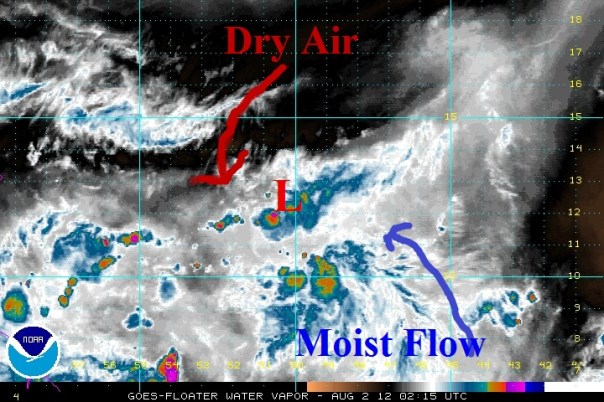
Overall satellite appearance had greatly improved since earlier this afternoon with canopy cloud coverage over the entire system until the last hour or so when convection fell apart. With the earlier blast of thunderstorms, the NHC went ahead and declared invest 99L a tropical depression at 5pm. Moderate shear aloft and dry air in the mid levels seem to be hitting the depression pretty hard at this hour with dry air easily showing up in the northwest quadrant, which was the stronger quadrant at times yesterday. Below is a recent water vapor image with dry air in brown/red:
Even though convection has diminished over the last few hours, it is quite normal for systems like this and even weak tropical storms to fluctuate during the evening hours. I fully expect an upswing in thunderstorms during the early morning hours. It will be interesting to see what the hurricane hunters find tomorrow afternoon when they fly in….that flight being scheduled at 11:30 tomorrow morning.
Currently, I believe the conditions are not good enough for the forecast intensity by the NHC to verify. I still think that there will be a general intensification by TD5 during the next 36-48 hours with the likelihood of an upgrade to tropical storm status coming after the hurricane hunter flight tomorrow or sometime on early Friday. The NHC put out a low-confidence forecast with then Ernesto being a hurricane in five days…with a five in ten chance that Ernesto will not even be a tropical storm or hurricane. I’m forecasting that once Ernesto reaches the Caribbean, the intensification phase will halt for 1-2 days with less favorable conditions in the eastern half of the Caribbean. Passage in the islands will likely include winds of 45-50 mph for a few of the islands closest to TD5 with higher winds in higher elevations. I think that once the system reaches the western Caribbean and the Yucatan passage (if it makes it that far north), it will be able to intensify once again with the warmer waters located there.
As far as exactly where TD5/Ernesto goes…I think it will continue on a WNW track into the eastern Caribbean with passage of the islands between Tobago and Dominica around noontime on Friday…in agreement with the NHC. Beyond that WNW track should continue into the western Caribbean, but I have less confidence with this part of the forecast since it will hinge on intensity. If I had to draw a cone, the center of it would be farther south than the NHC by about 20-50 miles. Typically, WNW motion would continue, but if Ernesto is stronger than forecast it could be farther north…more in line with the NHC.
Impact: The impacts this weekend for the islands will include tropical storm force winds for the 2-3 islands north and south of the center of the storm with winds up to 55-60 mph in the higher elevations. Rainfall could begin as soon as Thursday night in the easternmost islands with seas growing tomorrow to 6-8 feet. Seas could grow as high as 12-15 feet on Friday.
Further Updates:There will be another update in a few hours for those of you reading from Florida. There will be a tropical wave moving through the area later this weekend. At that time I will also have a few more maps for TD 5.
Posted on Wednesday, August 1st, 2012, in Tropical Weather and tagged Caribbean, Tropical Depression 5, Tropics. Bookmark the permalink. Leave a comment.


Leave a comment
Comments 0