Tropical Storm Ernesto Continues to Organize; Recon Investigating
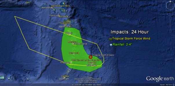
Hurricane hunters are on their way out to Ernesto at this hour with a second flight. During their first flight on Thursday, the hurricane hunters found winds of 50 mph and a closed center with a slightly faster forward motion. According to the 2am advisory and recent recon, Ernesto has maintained an intensity of 50 mph with a pressure of 1004 millibars. Forward motion at this hour is just north of due west at 23 mph. Ernesto is located 35 miles NNW of Barbados and will continue passing north of the island overnight. It will likely pass very near or just south of St. Lucia in a few hours. Tropical storm force winds are likely impacting Barbados at this hour and will be moving into the other islands including St. Lucia very soon. Winds will be gusty there for the next 12 hours with driving rains. Fortunately for Barbados, most of the thunderstorms will be north of the island, but St. Lucia and Martinique will suffer the strongest thunderstorms. Current watches and warning are as follows:
Remember that a tropical storm warning means that winds greater than 40 mph are likely to occur with in the next 36 hours. Tropical storm watches mean that winds greater than 40 mph are possible within 48 hours. In this case, these watches and warnings will likely only be in effect for 12 to 24 hours and will be canceled by sometime late Friday or early Saturday. The impacts will not be limited to winds as rains could add up to 4-5″ in the mountainous areas of the islands nearest and to the north of the center of Ernesto. These impacts are outlined below with the exception of high seas. As with any tropical system, do not enter the water until 48 hours after a tropical storm has passed your area. Seas could be higher than 10 feet on coastlines facing and perpendicular to the center of Ernesto Those impacts are as follows:
This storm will have some impact outside of the above watches and warnings and OUTSIDE the cone of uncertainty published by the NHC.
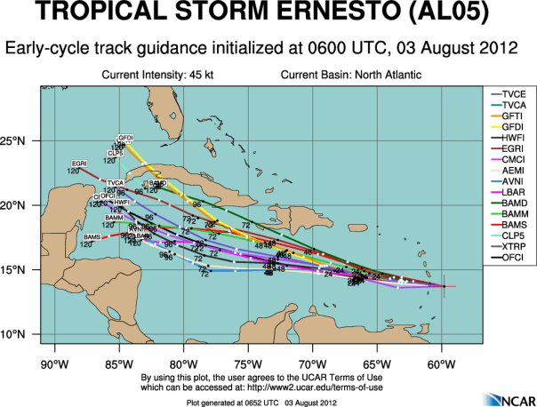
The forecast over the next 48 hours is fairly well certain. Ernesto will continue to track just north of west around the southern side of the Bermuda High for the next few days. Ernesto will enter the Caribbean Sea in about 4-6 hours and continue moving westward at 20-25 mph for 2-3 days. It’s on day four…or Monday…that things begin to fall apart…literally. Just about all of the computer models turn Ernesto to the WNW on Sunday when he will be south of Jamaica. At that point, Ernesto will ‘escape’ the flow of the Bermuda High and enter the lackluster flow of the western Caribbean and the Gulf of Mexico. We’ll talk about that forecast when we get there in a few days. For now I have attached the latest models below:
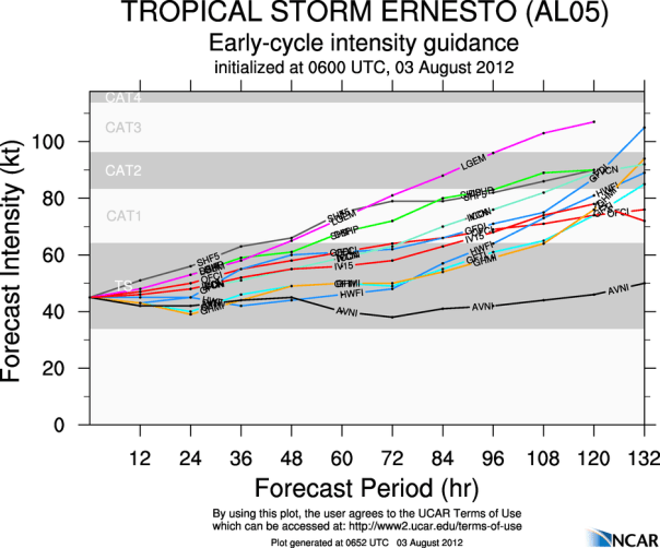
As far as intensity goes, my same thought process remains. Ernesto’s forward speed in itself limits any intensification that was possible before. Combined with upper level shear and some mid-level dry air (RH<60%), and I cannot forecast much if any intensification. Based on climatology, it is also known that the eastern Caribbean is generally prohibitive of growth. For those reasons alone, I believe that Ernesto will remain at 50 mph through the next 48 hours with 70% confidence. Conditions in the central and western Caribbean will be different in that Ernesto will be slower and will be traveling over water that is 2 degrees higher (F) than where Ernesto is now. The warmth of the Caribbean waters will also drudge deeper so even if Ernesto slows down, it will still have warmth to feed on. Remember that warm water is the heat that feeds the engine that is a tropical cyclone going. Upper level shear and mid level humidity will also become more favorable. The forecast: I’m not as bullish as the NHC on the intensity forecast and I will not be until I see that the favorable conditions will stick, but I could see that Ernesto could reach an intensity of near hurricane strength by Tuesday or Wednesday. Looking at the intensity models below, I am on the lower side of the intensity forecasts, but I am going to stick to that with Jamaica on my mind. I don’t want to increase the danger to that area, but as soon as I am sure that it will be a hurricane I will increase my numbers.
I’d like to return to the impacts of Ernesto on the Caribbean islands to highlight a learning moment. The strongest part of a cyclone in the northern hemisphere is the Right Front Quadrant…in this case it will be the northwestward side of Ernesto. Based on the latest satellite trends, the strongest part of Ernest is clearly on the northward side…which will include St. Lucia and Martinique. More on this subject has been included in tonight’s Meteorology Mumbo on the top right of this page.
Posted on Friday, August 3rd, 2012, in Tropical Weather. Bookmark the permalink. Leave a comment.


Leave a comment
Comments 0