Overnight Severe Weather Update. Slight Change in Timing…
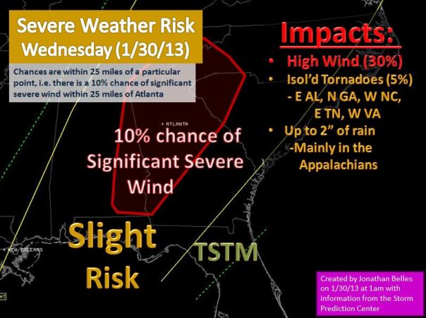
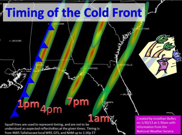
Make sure your weather radios are on tonight if you are east of the Mississippi or along the Ohio River. The line of thunderstorms is crossing the Mississippi River into Mississippi and Tennessee with numerous ongoing supercells. The Storm Prediction Center has retained the slight risk for everyone along the Appalachians and eastern Gulf Coast with the main threat being severe wind for tomorrow. The main change tonight is a slight quickening in timing of arrival. I have bumped up the arrival times from my last post in accordance to tonight’s model runs, but I did not quite match the gfs/nam timing. The low level jet, and the source of most of today’s wind, is currently aligned SW to NE in Mississippi and is slowly moving eastward with the front. This will cause winds outside your door to increase after sunrise. Winds on land will be sustained at 15-20 mph, with gusts as high as 45 mph outside of thunderstorms. Winds could be as high as 70 mph in any thunderstorms that contain considerable downdrafts (severe storms). In the Gulf, forbidding anyone goes out today, winds could be as high as 30 mph sustained with seas as high as 10 feet. Best Advice: Stay on land tomorrow. Conditions will return to smoother waters by the weekend.

Below is my expected impacts map with the outlook from the SPC and my thoughts on timing:
Posted on Wednesday, January 30th, 2013, in Florida Weather, Severe Weather. Bookmark the permalink. Leave a comment.


Leave a comment
Comments 0