Tough Environment Dries Out, Displaces, and Disorganizes Dorian
We knew that the environment ahead of Dorian was far less than ideal, and that there would be a better place for Dorian in a few days. What I did not expect was a complete demise of Dorian today. Early day ASCAT passes showed that Dorian had opened up into a very sharp wave, but Dorian fought back by mid-day and regained a low-level closed center. Since the early evening, the upper levels were whisked away of the lower parts of the storm and convection has just about completely fallen apart. As of 11pm, the National Hurricane Center has kept Dorian alive as a tropical storm, which I somewhat disagree with. The satellite appearance is now more of the inverted V shape, which is what we expect to see with a tropical wave. Convection over the last two hours has redeveloped, but it has developed in a linear band that stretches from SW to NE.
Below is the latest satellite images and probably the numbers from the National Hurricane Center:
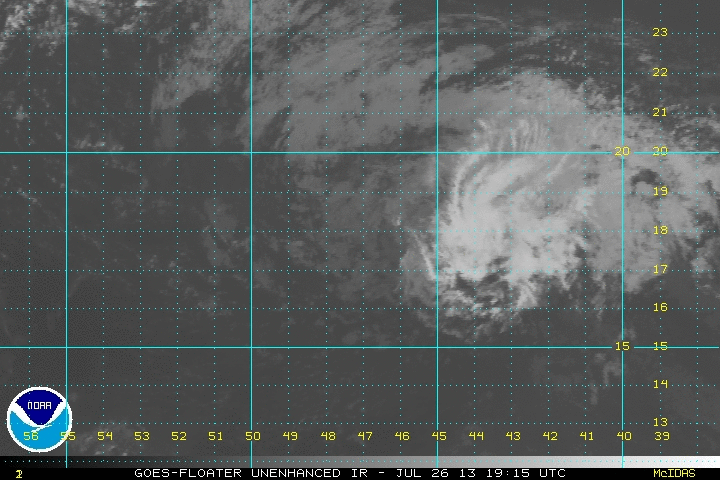
Location: 17.9°N 48.1°W
Moving: W at 22 mph
Min pressure: 1010 mb
Max sustained: 40 mph
If Dorian can gain a bit of latitude, I would not be stunned by a reorganization in a few days. Shear is expected to come down by then, and the warm Bahamian waters will be in play. Over the next few days, Dorian will slow down, which will help him organize a bit. Two things will have to happen in order for regeneration:
- A Mid-level center will have to remain intact all the way to the Bahamas
- Dorian will have to gain more latitude than currently forecast, and the models are trending toward the south. The Bermuda High will have to be weaker over the west Atlantic than currently forecast when Dorian reaches that area.
Overall chances of reorganization are small, although not impossible. At this time I do not expect any reconnaissance activity over the next couple of days. What I do expect is a couple flare ups of thunderstorm activity over the next 24 hours, both big and small. Portions of the Leeward Islands and all of the Greater Antilles will want to watch any thunderstorm activity that persists for longer than a few hours. Puerto Rico has been enduring a relatively rainy period as of late, and any additional rainfall could create flooding. Any rainfall at all could lead to flooding on the island of Hispaniola.
I will take another look at Dorian tomorrow night, as well as a look at the eastern/central Pacific tropical storm that may impact the Hawaiian Islands next week. You may remember the name, Flossie, from 6 years ago when a storm with the same name brushed by the southern shores of Hawaii.
I’ll post the latest updates on Dorian on twitter @JonathanBelles 24/7 and Google +.
Share this!

Posted on Friday, July 26th, 2013, in Tropical Weather. Bookmark the permalink. Leave a comment.

Leave a comment
Comments 0