TS Arthur Strengthens to Near Hurricane Strength: Hurricane Warnings Hoisted
As expected, today was a day of slow intensification and abundant monitoring. All resources continue to be used to monitor Arthur, and this storm continues to follow guidance from days ago. Thus far this is a well forecast storm. As of 11 pm, the information from the NHC are as follows:
- Winds: 70 mph
- Pressure: 988 mb
- Location: 380 miles SW of Cape Hatteras, NC
- Movement: Due north at 8 mph (slightly faster from last advisory)
Current Status:
Arthur has gained a well formed eye today and has greatly improved it’s structure with a complete eyewall at times this afternoon. Winds at times were within 1 or 2 mph of hurricane status. Arthur’s eye remains cloudy. The eastern and southern side continues to be the strong side of this storm, however banding on the western (land) side of Arthur have been strong to severe at times. We should see improved thunderstorm activity on the northern side over night. The eye should also clear out as intensification continues.
Where We Go From Here: Forecast Intensity
Intensity is the bigger variable in this forecast. Dry air has been the biggest battle thus far, but even with that in place Arthur continues to intensify. Shear thus far has been limited, but not zero as seen below as the yellow lines in knots. Shear will become a major factor in 2-3 days or so, but for now it is not inhibitive. Fuel from below in terms of very warm waters and somewhat depthy warm waters has helped Arthur organize and intensify. The waters are even warmer ahead as the cyclone parallels the Gulf Stream over the next day or so. I fully expect to wake up tomorrow with a hurricane off the coast. Thursday will be an intensification day for Arthur, and it should continue to intensify until either landfall or until it leaves the Gulf Stream on early Friday morning. Thankfully Arthur will accelerate toward cooler waters and land tomorrow as well. One final factor that will affect Arthur’s intensity will arrive late tomorrow in the form of a somewhat abnormal cold front and trough. Troughs this time of year are not out of the ordinary, but front this strong are. That trough will add energy and speed to Arthur’s envelope, which will unfortunately drench eastern New England during the fireworks and it may add some extra strength as well. There is a narrow window where that intensification kick could occur before major shear moves in from the cold front. The current NHC forecast brings Arthur up to 85 mph, and I have no reason to argue with that. Maximum intensity should occur shortly after interaction with North Carolina, somewhere off the coast of the mid-Atlantic states.

Forecast Track:
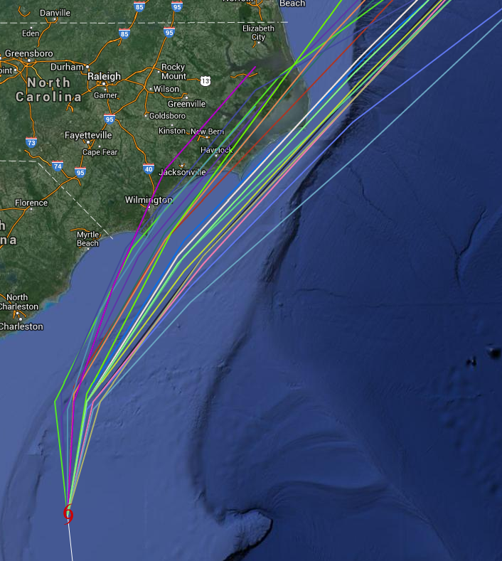
I must stress to you that you skip this section, go on to the next one and then come back to up to this one before reading into any of the lines of the next graphic. Each of those lines are a different model recently produced. These models have the data from the hurricane hunter flights this morning and early afternoon. Consolidation of the track models has been good thus far. Impacts will likely reach well into inland North Carolina and the mid-Atlantic on Thursday and into Friday. It is important to stress that the eye and eyewall may come very close to the barrier islands of North Carolina, impacts will be felt inland as well. Hurricane Warnings are in effect for much of the NC coastline, and an evacuation order has been put in place for Hatteras. My professional opinion is that this will make landfall on the barrier islands as it passes through unless rightward wobbles occur, but lately leftward wobbles have been more common. Models indicate that a good deal of this system’s effects will be felt on the left or westward side as it brushes New England on July 4th.
Impact:
- Wind: Winds of hurricane force will be felt near the eyewall of to-be-hurricane Arthur with tropical storm force winds extending 90 miles outward from the center. This wind field is expected to expand as it travels northward.
- Waves: 12-20 feet on top of storm surge. Enjoy the beaches this holiday weekend if you do not have to evacuate, but do NOT go in the water!
- Storm Surge/Inundation: 2-4 feet on the outer banks and in some of the outlets. If you are on a low lying island of on low lying ground, water there may rise up to 4 feet.
- Rainfall: 2-4″ of fresh water is expected to fall in eastern North Carolina and in eastern New England as Arthur passes by. Heavier rainfall will occur closer to the eyewall over water

The Bottom Line:
A hurricane will approach eastern North Carolina tomorrow night into Friday (July 4th) morning with hurricane force winds, torrential rainfall, and very choppy seas. Prepare for a hurricane 1 or 2 categories stronger than forecast so that you are not caught off guard. Fireworks for Independence Day should go off without a hitch up and down the eastern seaboard with the exception of New England. Unfortunately, those displays will have to be delayed or cancelled due to weather. The weekend looks good. Hurricane Hunters will fly once again this evening and tomorrow morning as long as needed.
Stay tuned on twitter @JonathanBelles for updates,
–Jonathan
PS -> These posts should be posting to Google Plus now as well. Find me there +Jonathan Belles
Share this!

Posted on Wednesday, July 2nd, 2014, in Tropical Weather. Bookmark the permalink. Leave a comment.

Leave a comment
Comments 0