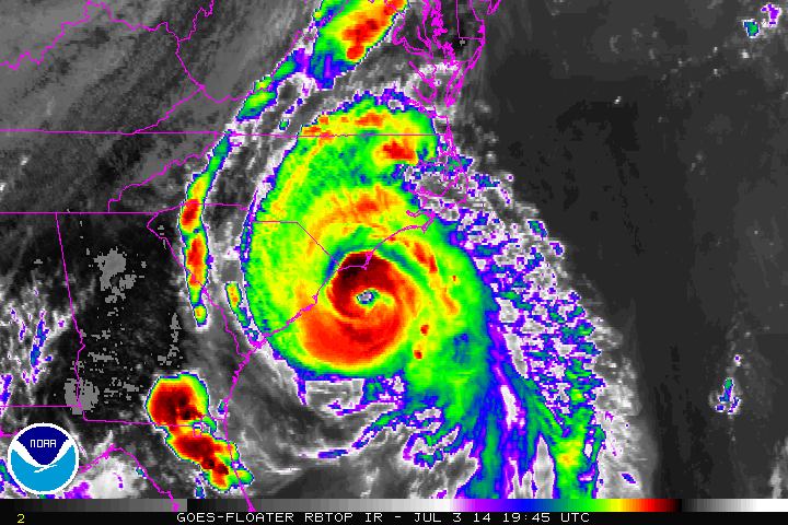
Hurricane Arthur Becomes a Category 2: Making Landfall Now
A long night is ahead in coastal North Carolina where winds above 75 mph will reach a good portion of that area. Tornadoes have been possible across northeastern North Carolina this evening, and the threat for tornadoes continues into tomorrow morning ahead of Arthur. A tornado watch is in effect for most of eastern NC for this threat until 8AM. Winds near 100 mph are visible on radar near Beaufort and Harkers Island, NC coming ashore in the northeastern eyewall. Gusts are possible well over 105 mph. Please see official sources (local officials and the NHC) for official information. Landfall officially came at 11:15pm near Beaufort, NC. Current information from the NHC is as follows:
- Winds: 100 mph (Category 2 Hurricane)
- Pressure: 976 mb
- Location: Nearing Beaufort, NC and Cape Lookout, NC
- Movement: NNE at 18mph, acceleration expected to continue

Impacts tonight into tomorrow morning:
- Wind: Sustained at 100 mph and gusts to 115 mph for much of Hatteras Island and the eastern part of North Carolina to the right of where Arthur tracks
- Rainfall: 2-5″ of rainfall will occur on Hatteras Island and eastern North Carolina and extreme southeastern Virginia. 1-2″ of rain for central NC, SE VA, and the southern Delmarva.
- Tornadoes: Possible on the northern side of Arthur as it tracks northward. These should be short lived and weak
- Surge/Waves: Waves up to 20 feet will top 3-5 foot storm surge on Hatteras island with lower numbers in the sound of eastern NC.
- Erosion will continue on eastward facing beaches
Tomorrow Night/Saturday Morning:
- Winds may reach 40-60 mph in eastern Massachusetts as Arthur passes to the east. Any deviation to the west in track may bring hurricane force winds to that area
- Rainfall: 2-4″ of freshwater rainfall is probable in eastern Mass, Rhode Island, and parts of Long Island
- Waves will climb along the coast of the mid-Atlantic states and New England.
- 4th of July: Likely rained out in eastern New England. Do NOT go in the water!!

Occurring Now:
Landfall is occurring now near Cape Lookout. The strongest rain band is off shore with winds topping out near 100 mph in the southeastern quadrant. No major changes have occurred in the recent few hours, but some deterioration is possible why Arthur is overland. Something interesting is occurring in the eye, but that information can be seen at the end of this post.
The Forecast:
Arthur will track over eastern North Carolina overnight bringing the impacts mentioned above. Small deviations in track is possible due to friction with wobbles. Arthur should be moving away from North Carolina around sunrise tomorrow morning. Due to enhanced interaction with land, intensification is not expected over the next 24 hours. After that time, the trough we discussed yesterday will be interacting with hurricane Arthur and weakening should commence. The balancing act between weakening induced by the trough and intensification due to acceleration should allow slow weakening off the east coast of the US. Interaction with Nova Scotia late on Saturday will commence the final weakening trend.
The Eye Story: Extra Information
Breezing over radar imagery earlier I saw what appears to be birds or bugs stuck in the eye of Hurricane Arthur. I said appears because there is no official confirmation on this, but this is how I came to that information. Current reflectivity radar, and snapshots from earlier in Dual Pol. High ZDR means that the radar is picking up flat horizontal objects and low CC means that the objects are likely not rain. What is long, flat, and not rain: My first thought was birds with wings, but birds or fluid trapping are also possible. Opinions welcome!

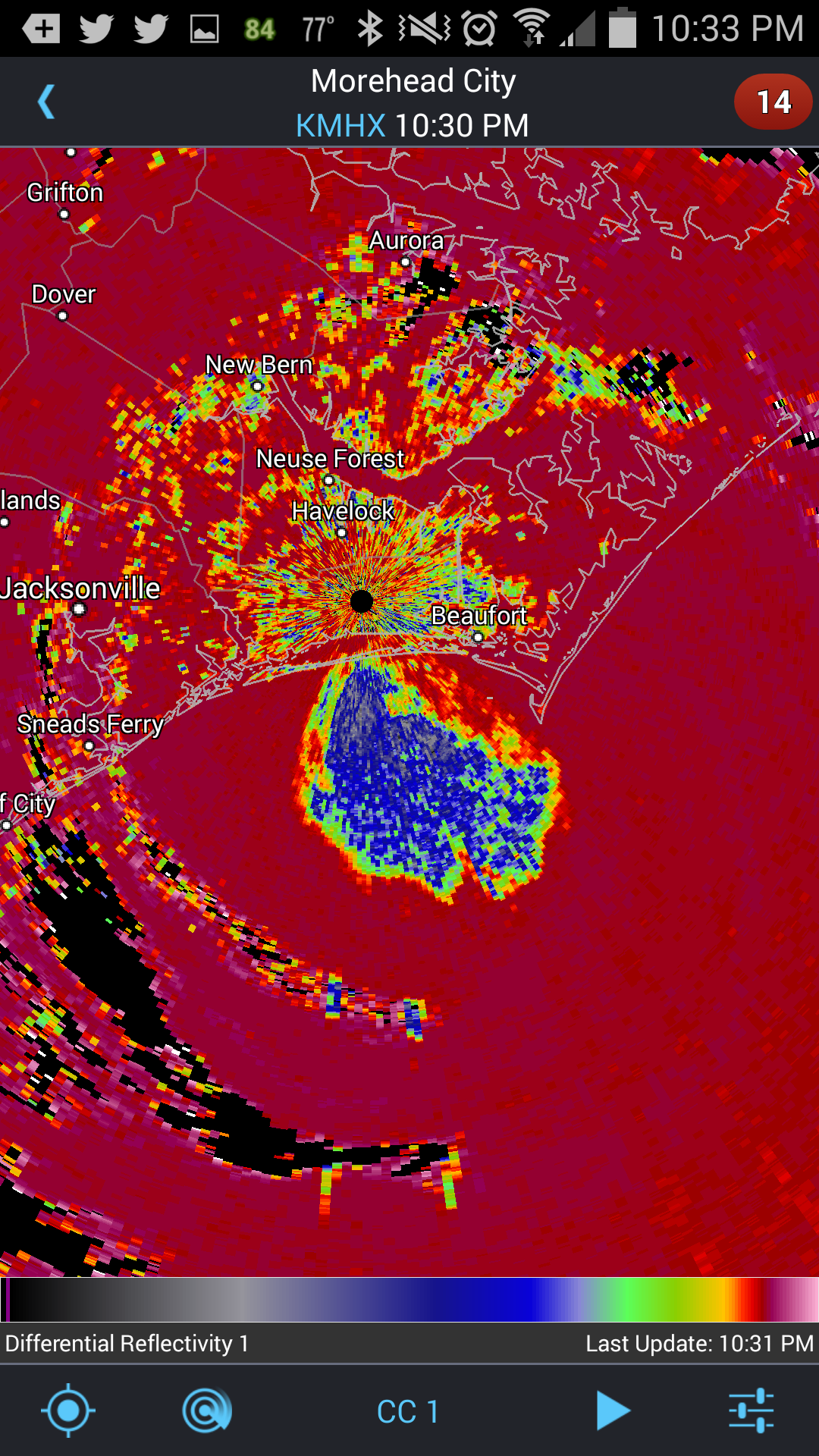
Correlation Coefficient in the eye.
ZDR in the eye.
As always, i’ll be updating on twitter @JonathanBelles
-Jonathan saying “Stay Safe!”
Share this!

Posted on Thursday, July 3rd, 2014, in Tropical Weather. Bookmark the permalink. Leave a comment.

Leave a comment
Comments 0