Abnormal Cold Front To Reach Florida as the MDR Moistens
Although the weather this afternoon is comparatively quiet (albeit dangerously warm in the panhandle) in Florida, the troughing pattern that has been with us on the east coast for a few weeks is about to bring down an unseasonably strong cold front. The Storm Prediction Center had initially issued a summertime Moderate Risk of severe weather for the central Appalachians into this evening for the system coming out of Canada. In their latest update, they have outlined a reduced but still enhanced risk for much of the area. That same front could produce severe weather tomorrow from the coastal Carolinas to southern Mississippi. It is not surprising that a rare front could produce severe weather. In Florida, we don’t even need a front to receive severe weather as seen by the EF1 tornado on the space coast recently.
How far south with the front go?
The Weather Prediction Center has had this front dipping as far south as the Cape Coral to Lake Okeechobee area, but their most recent forecast halts southern motion across Interstate 4. Below is the current WPC/GFS Depiction:

WPC/GFS Depiction on Thursday morning. Dew points are shaded. Lifted index is contoured.
Interesting in the above graphic is that dew points could fall below 65 along the spine of the state, but also the lifted index is positive. A positive LI generally means sinking air. This depiction is for the morning time, so storms probably would not be prevalent anyway, but it is interesting nonetheless. This may keep storms down on Thursday, but given that dry air aloft is already keeping storm chances down this week you probably won’t notice too much of a difference.
How Low Could Dew Points Go?
The general trend is that the farther south you are, the less impact there will be and the impacts will be later. As we saw with the last front (which only made it to Tallahassee), impacts could be seen 100 miles south of this front, which shows up well in south Florida and on the map above. I have chosen three sites to plot on meteograms, and GFS (in blue) picks up the dip in dew points well. Tallahassee could again have a dew point in the mid 50s on Thursday Morning. GFS has Tampa dew points dipping into a more comfortable range for quite some time late week, and dew points in the 60s even into south Florida on Friday. It is interesting to note that the NWS (in green) is not really biting on these lower dew points, but I don’t blame them. Some of these drops could be almost historic…especially in Tallahassee. Confidence is high that dew points will drop as this front approaches.

Any cooler air coming?
Probably not. Temperatures north of I-4 could drop a couple of degrees, and there is a subtle lowering in high temperatures toward the end of the week. The cool factor will come mostly from the drop in humidity. Confidence in this is in the low category due to the lack of the entire model suite at that time, the irregularity of the event, and the normal variability in cloud cover during the summer. Up to the north? Yes, this will drop temperatures for 2/3rds of the country!
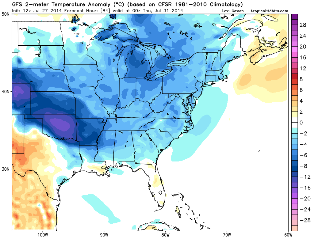
Temperature Anomalies from the GFS on Thursday Morning. In Celsius, but the take away from this is that blue/purple is cooler than average air.
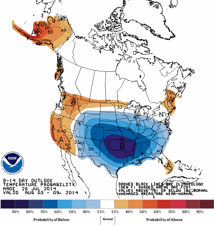
Long term temperature forecast for early August. Again, cooler than normal in blue. From the CPC.
You say more active tropics, will this front spawn anything?
As of right this second…no. That is not to say that this pattern will not spawn a homebrew system in the weeks to come. Pressures are expected to be lower than normal due to the troughing pattern, and with fronts lingering in the area we have a ‘kick’ for something to develop on in a similar way that Arthur did.
There is something to talk about in the Tropics right now, and it comes from the MDR.

This system has a slightly better development chance than TD2 did because the air ahead of this disturbance is slightly more moist, however shear is considerably higher now. Tracking of this system is difficult due to the lack of any organization, but organization is expected to become better in the days to come. Current models bring this system (as a vorticity maximum) toward the central or northern leeward islands. I’ll be keeping my eye on this and the rest of the tropics all week.
For more frequent updates, follow me on twitter @JonathanBelles! Send me questions too!
Remember, if you have to take your kids to the store or anywhere else…put your phone in the backseat so that you have to retrieve it when you get to your destination. This way, you will not forget your kids in the hot car AND you won’t be texting or talking on the phone while you are driving. Turn your ring tone to something fun so that if your phone does ring, your kids can dance!
Until next time,
–Jonathan
Share this!

Posted on Sunday, July 27th, 2014, in Florida Weather, Severe Weather, Tropical Weather. Bookmark the permalink. 1 Comment.

Nice blog!!
LikeLike