Drier Air Dictates The Forecast for Florida and 93L
Drier air is filtering in to a lot of places this evening. For most of us east of the Rockies, this is a good thing….and I am not just talking about here in Florida. Dry air has also leached into 93L today, which is good news so far for the northern Lesser Antilles.
Let’s start in Florida tonight where the unseasonable cold front is moving through the Big Bend Region:
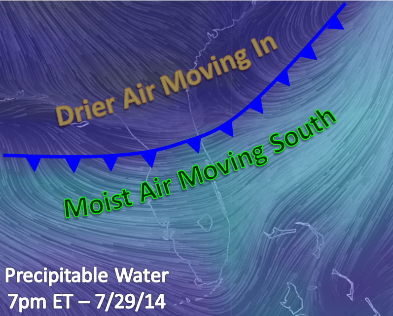
Record lows could occur tonight in north Florida as the drier air moves in. Drier air allows for enhanced radiational cooling. This along with some cooler air from the north, temperatures there should fall into the mid to upper 60s except for right along the warmer gulf waters. The real change across the northern half of Florida will be the drier air that will certainly make it feel cooler than it has been. Feels like temperatures in Tallahassee and in surrounding cities have been 108°F or more in recent days. In the next couple of days, feels like temperatures could be as much as 20 degrees cooler as dew points could be low enough that the air could feel like the actual temperatures.
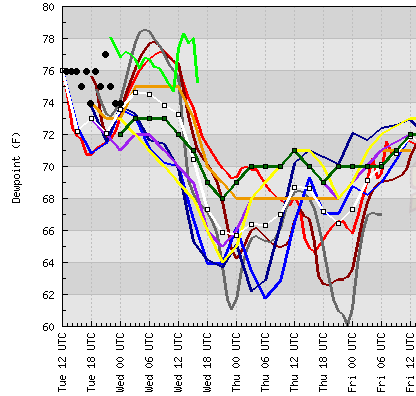
For central Florida, it will take another day before this drier air truly moves in with dew points in the upper 60s and lower 70s. The below meteogram from IA State for Tampa shows that the dew points could fall as far as the mid 60s there, but this seems a bit generous. I think the actual low dew point in Central Florida tomorrow night or Thursday morning will fall between the NWS (in green) and the model avg forecasts (in white)…or into the mid-upper 60s. South Florida low dew points should be on Thursday morning in the low 70s.
Is Dry Air Killing 93L?
In short, no. Dry air has gotten entrenched into the eastern and northern side of what I actually think is tropical depression #3. I’ll be using the two terms, 93L and TD3 interchangeably here, but please refer to the NHC for official information. As I said yesterday on twitter, I do believe this system became a tropical depression last night as a closed, although slightly elliptical, center and abundant thunderstorm activity became apparent. Unfortunately, when dry air reached 93L’s center this morning that thunderstorm activity became limited. 93L currently resides on the line between a tropical cyclone and a tropical wave.
The road ahead of 93L is a tough one due to dry air, slightly cooler water and high shear. The next 4-5 days carry the danger of dissipation if any of the aforementioned factors become overwhelming. These factors should keep this system less intense. Current reliable models keep what still should become Bertha as a weak tropical storm as it approaches the Lesser Antilles.

Cross section of the HWRF 18Z run for 93L at 24 hours. Abundant dry air can be seen above 500 mb (18,000 ft) intruding through the center. From Tropical Tidbits.
The current spaghetti models bring this system toward the central or northern Lesser Antilles in about 4 days (Friday or Saturday). As discussed above, I do not think this will be able to become more than a moderate tropical storm especially if it is flirting with land. The grand scheme of the forecast is that 93L will be moving around the edge of the Bermuda High at the surface and between two ULL features aloft. How much latitude is gained over the next week will be dictated by how strong the system becomes. A weaker system will be located farther from the Bermuda High, and a stronger system will be located closer to the Bermuda High and thus farther north. The current trend is for a weaker system that will track farther south and west.

In some ways, this trend is a friend in more ways than one. Many locations in the eastern Caribbean are in a slight and worsening drought. Roughly 10% of Puerto Rico is under drought, and more than half of that island are abnormally dry. Rainfall from 93L could prove to be good for these islands if the system is weaker as it moves through. I do want to mention that there is NO correlation between weaker systems and beneficial effects, but with this system and in this condition it could be beneficial for the islands.

After 5 days, we could see a period of intensification if this system is still alive. This is in part due to warmer ocean temperatures and a favorable pattern aloft for thunderstorms to grow.
As always, I’ll be watching.
–Jonathan, @JonathanBelles
Share this!

Posted on Tuesday, July 29th, 2014, in Florida Weather, Tropical Weather. Bookmark the permalink. Leave a comment.

Leave a comment
Comments 0