93L Fights Back Against Dry Air
Good evening all! Just a short update tonight as I want to enjoy the slightly drier air that both southeasterners are enjoying. 93L ceased to exist as a tropical depression this morning at around 12z (or 8am ET) as shear took over and shoved drier air into 93L’s core. Take a look at the image below. There are a few notable things here: shear direction and the band of showers to the north.

The actual local of the center is on the NNW side of the eastern most thunderstorm complex (marked by the red I). That product is from CIMSS. The shear is directed from the drier northeast into the more moist SW. At the surface, this dry air was advected into the cyclone last night, and 93L is just now regaining thunderstorm activity. The amount of shear in itself isn’t too terribly hazardous for the system, and levels are expected to be similar over the next 48 hours. The direction of that shear is more important here.
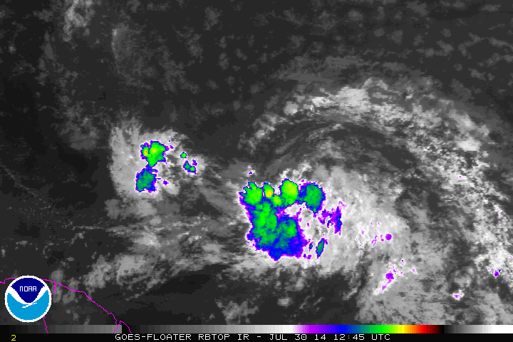
Add on to that drier air, the cooler waters of the near Caribbean waters and 93L continues to have a tough battle ahead of it. If thunderstorm activity can get to the weekend without getting ragged (like the rest of us, eh?), it may have a better chance of development north of the Caribbean. That northern rain band you can see on satellite may help. That northern band of clouds is a sign that air from the system is hitting something of a different kind of air…the drier Saharan air. Think of it like a front or boundary between two air masses or maybe even a shield for the system.
I mentioned in the last post that the Lesser Antilles are in the midst of a light to moderate drought. Today, news came that the government in Puerto Rico may begin water restrictions on the island starting between August 6th and the 14th if conditions do not improve. Water would be restricted to once every other day use of water. This system, should it remain on track toward the northern Leeward Islands, could help the drought and hopefully make the authorities there rethink this decision.
This tropical wave/low pressure system may not be the last we have to watch, and this swirl behind or to the east of 93L may have to be watched as our next system.

If you have any outdoors work that you should be doing this summer, tonight or tomorrow morning might be the best day to do it because of the lower humidity. Don’t forget the special episode of WeatherBrains and Sharknado 2 tonight!
See you all soon,
–Jonathan, @JonathanBelles
Share this!

Posted on Wednesday, July 30th, 2014, in Tropical Weather. Bookmark the permalink. Leave a comment.

Leave a comment
Comments 0