Tropical Disturbance Approaches the Windward Islands: Coin Flip Chance of Development In The Long Term
Good morning!
A small and disorganized area of low pressure has caused quite a ruckus in the meteorological community over the last day. Why does such an average and ordinary tropical wave catch so much attention? This invest (denoted 96L by the NHC) has models pointing toward the very warm waters of the Caribbean. This would be the first wave of the season to enter those waters with thunderstorm activity if it makes it there. Right now the NHC give this invest a 50% chance – a coin flip chance – of development through the next 5 days. Chances are in the medium category – 30% – through Friday morning…the window where we should be watching rather than the long term.
BUT
There is meager model agreement with this one. The GFS ensembles (a group of sub-models with small changes to the GFS) have this system ending up in Bermuda, or in Cuba, or in North Carolina, or in Louisiana. There a majority of models along the northern Caribbean, however the fact that some of the ensembles are very much outliers shows there is not a firm agreement in track. The intensity forecast isn’t any better. Remember there is still a chance that this thing dissipates.

Ensemble members of the GFS
These models really cannot be trusted at this point with anything more than telling us that shower activity, moisture, and gusts will be on the increase in the Caribbean over the next few days.
Unfortunately there are a select few (Kevin Martin, I’m looking at you) that will say that this will be much stronger and it will approach on Labor Day weekend. Let’s not get ahead of ourselves and take the weather for what it is. This is a cluster of thunderstorms east of the Caribbean, which is an area so far that has not been overly ripe with thunderstorm or tropical activity thus far. This system only has a 30% chance of development into a tropical cyclone within the next 48 hours. That means that there is a 70% chance that this will be a tropical cluster of thunderstorms as it moves through the Windward Islands. Most development will be over the weekend into next week. Plenty of time to watch this system.
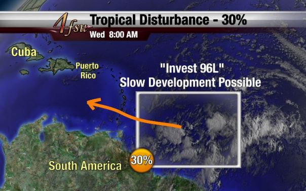
- Note: Graphics may occasionally be used from FSU Weather now that I am back in Tallahassee. Graphic created by Jonathan Belles.

This will be a gradually developing system, at least in the first few days. We’ll still be dealing with shear and dry air just like the other systems earlier this year. We’ll talk more impacts over the next few days. Don’t change your plans unless you’ve got a picnic on the beach planned in the windward islands Thursday or Friday (and even then I probably wouldn’t change too much).
For now, let’s just look at the more timid – but hazy – sun and moon from this morning in Tallahassee. Thanks to NWS Tallahassee and the local winds for the opportunity to shoot the 12Z weather balloon launch and the moon.

Weather balloon floating “above” the moon with radiosonde drifting below. What is a radiosonde? Check out this week’s Meteorology Mumbo!
Have a great day! If you’ve got weather photos, send them to me!
— Jonathan, @JonathanBelles with more images to come on twitter throughout today
Share this!

Posted on Wednesday, August 20th, 2014, in Tropical Weather. Bookmark the permalink. 1 Comment.

Greetings from Idaho! I’m bored to death at work so I decided to browse your site on my iphone during lunch break.
I enjoy the information you present here and can’t wait to
take a look when I get home. I’m amazed at how
fast your blog loaded on my cell phone .. I’m not even using
WIFI, just 3G .. Anyhow, awesome blog!
LikeLiked by 1 person