Effects of Protostorm-Bill Already Being Felt Ashore: System and Residents Organizing
“If it looks like a duck and behaves like a duck, then you should probably prepare for it like a duck. #BePrepared”
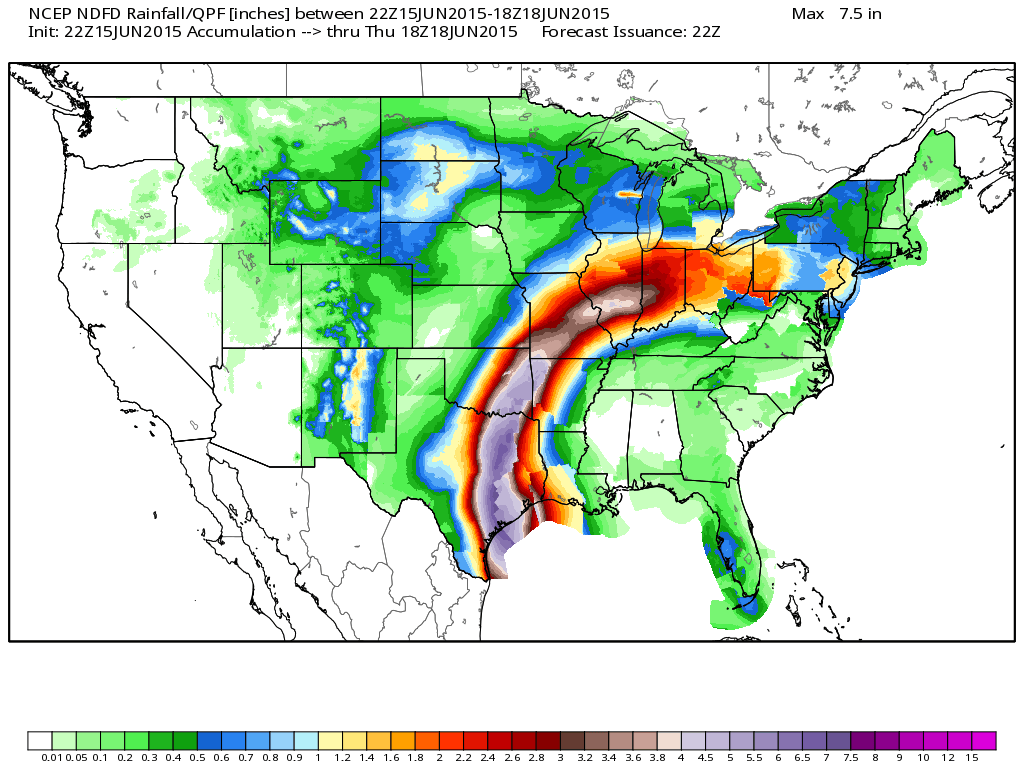
That is a tweet I sent earlier today, and that is the mentality I will be using when writing tonight’s update. In all but one aspect, the system in the northwestern Gulf of Mexico is a tropical storm, and one that means business. NHC will likely upgrade this system at or before 10pm CT. The tropical stream extends from the Gulf of Mexico to New York Harbor and flood watches are in effect in a dozen states. The rainfall forecast has been in place for a few days now, and it did not change much today. The official forecast (below, from WeatherBell) calls for 3-7″ of rainfall along and east of Interstate 35. Some localized amounts could be upward of 10-15″. WPC is advising that there is a moderate risk of flooding for the mid-Texas coast and a slight risk of flooding throughout most of eastern Texas and Oklahoma.
From WeatherBell/NWS
Impact:
As I did yesterday I am going to leave the meteorology toward the end and start with the impacts:
- Rainfall: 3-7″ of rainfall is expected in a widespread fashion from Houston to Victoria and up to Dallas and St. Louis through Thursday. Isolated spots may see as much as 10-15″ on very saturated soils. Flooding is imminent in coastal Texas. Flood watches are already in effect for much of Texas and Oklahoma. The worst impacts will come tomorrow and Wednesday in these locations.
- Coastal Erosion/Surge: A strong fetch out of the southeast is already bringing in not-so-much needed rainfall to SE TX/SW LA, but it is also raising tidal levels there as well. It does not take a tropical system to produce surge. NWS LCH is already forecasting tides to range 2-4 feet above average low tide levels through Tuesday. Small levels of inundation, especially at high tide, is possible. A coastal flood warning is in place.
- Rip Currents: Where the winds are blowing at 90 degrees to the shoreline, expect rip currents early this week. Overall, it is not a good beach or boating week to start.
- Wind: Winds are expected to be on the low-end of the tropical storm spectrum, probably around 55 or 60 mph at landfall with higher gusts. Saturated grounds may allow gusts to blow over trees and other objects.
- Tornadoes: A brief tornado or waterspout is possible in western coastal Louisiana or the upper Texas coast in feeder bands tonight and on the right-front side of this system tomorrow.
Official Information:
- Maximum Winds: 45 kt/50 mph
- Minimum Pressure: 1007 mb (1002 mb found on recon)
- Center Location: 26.2N, 93.3W
- Chance of development: 90% **From NHC 8pm TWO: “If these trends continue, advisories will be initiated later this evening on Tropical Storm Bill”**
- More official information: http://www.Hurricanes.gov
- NWS Houston: http://www.srh.noaa.gov/hgx/ ; NWS Corpus Christi: http://www.srh.noaa.gov/crp/
- Some voluntary evacuation orders have been issued for Bolivar Peninsula. Check in with local authorities.
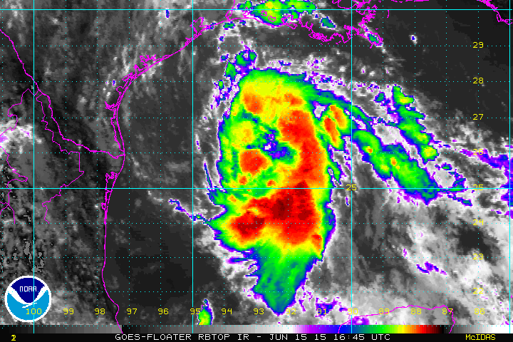
Hurricane Hunters are making their third voyage through this meteorological challenger of social science. They have so far confirmed winds of tropical storm strength removed from the central dense overcast, but the surprise comes from the pressure department. As of 8pm, they have found a minimum pressure of 1002 mb. This recon mission was a mission to find a distinct center of circulation and you can see that by the pattern that recon flew…not the normal alpha pattern. Winds have increased to near 50 mph. Winds weakened as the Hurricane Hunters approached the center on both trips through. That recon mission is now over.
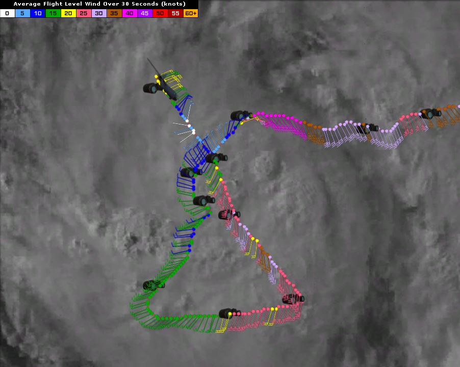
Full recon flight through 00:20Z
The Less Important Part: The Meteorology
The meteorological process that takes an upper level trough down to the surface in a tropical manner generally takes a couple of days to complete. This system is on a tight schedule to do so while it is in the water, but it seems to be on the fast track. It seems that there may be some miscoupling of the mid-level and low-level centers, and that is evident when you compare satellite and recon observations. Recon entered the small dense overcast where the center is thought to be and the winds immediately dropped. They did however find weaker near surface west winds, which is generally a sign of closure. Satellite images continue to impress with a band set up on the eastern side as one would expect with a moderate tropical storm and a central dense (but bottom barren) overcast. ASCAT earlier in the day showed a very large wind field.

16z ASCAT
With the speed that this system is organizing and the minor overperformance in the intensity department, I see no reason that minor intensification could not occur before landfall tomorrow morning. Intensification will be limited by the disorganization of this system. There still seems some sentiment in the models that intensification may occur overland in 48 hours or more, but again we’ll cross that bridge when we get there.
Decently curved forecast hodographs this evening show that there is a small chance of coastal tornadoes from Lake Charles perhaps to Matagorda Bay at least through sunrise or a few hours before. Precipitable water values in that same area and inland are already above 2.2″ and should climb as the system approaches. PW records should be close to breaking or be broke in the next couple of days. That will assist excessive rainfall totals.
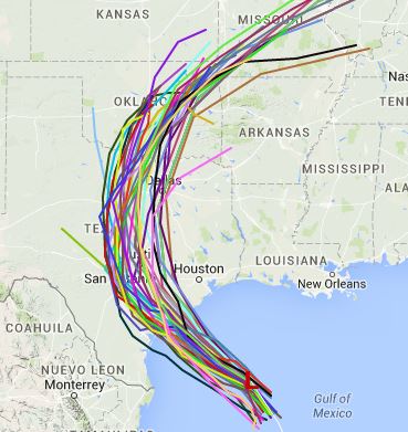
As far as track goes, you can pretty much follow the western edge of the highest rainfall totals in the map at the beginning of this post. It appears that the least important part of this system (the center) will pass near Matagorda Bay with most of the impacts being felt off to the east. There is lower than normal confidence in the forecast once the system enters Texas until it reaches the mid-Mississippi River in 2-3 days (Thursday-ish). I am showing the spaghetti plots today when I didn’t yesterday due to the uncertainty in that forecast and because it gives a decent western edge of the heaviest rainfall.
From Tropical Atlantic
Bottom Line:
This metaphorical duck is coming ashore tomorrow morning or afternoon with very heavy and excessive rainfall, winds of 50 mph, and minor coastal inundation. The legacy of this system will be the water in eastern Texas and eastern Oklahoma. Whether this thing has a name or not is not very important because there is no magical light switch that turns some impacts on or off when a system gets named. Treat this ducker like a tropical storm, and prepare for a moderate tropical storm or a massive rainstorm.

From aboard the ISS. Taken by Scott Kelly.
Stay safe, and go Bolts! Stay dry too.
–Jonathan, @JonathanBelles
Share this!

Posted on Monday, June 15th, 2015, in Tropical Weather. Bookmark the permalink. 1 Comment.

Pingback: 11pm Bill Round Up | Eye on Weather