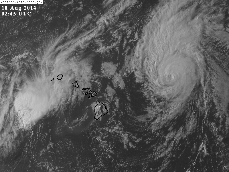
Julio Turns Up Waters North of Hawaii, Iselle Brings Heavy Rain
Residents on all of the Hawaiian islands are picking up damage and recovering from flooding from Tropical Storm Iselle. Conditions on a few of the islands have turned back to normal in terms of weather, however winds will be turning from the north tonight as Julio moves in. Rainfall continues from Iselle on Oahu and Kauai and the western atolls. Most of this rainfall is coming to an end, but not before dropping buckets of rainfall last night.

Selected Rainfall Totals As of This Morning:
- Kulani – 15.25″
- Glenwood: 14.76″
- Kilohana – 9.58″
- Mount Waialeale – 7.56″
- Puu Kukui – 6.88″
- South Point – 4.99″
- Pupukea (USGS) – 4.22″
- Pahala – 3.82″
- Hilo – 4.13″
- Mauna Loa Observing Station – 2.19″
- Molokai – 1.22″
- Honolulu – 0.42″ (in the rain shadow)
- Kona Int’l – 0.04 (in the rain shadow)
A full list can be found here: http://www.prh.noaa.gov/data/HFO/PNSHFO.1408092020
Flooding has become a problem on numerous of the islands. Numerous streams and rivers are well above normal. Despite the caption being wrong, this video from NBC shows a great representation of how much water cal flow even after a tropical storm: http://www.nbcnews.com/news/weather/see-hurricanes-awesome-effect-waterfall-n176346 . Rainfall is still occurring in Kauai and the atolls, and recent convective bursts may keep Iselle’s skeleton active for another couple of days. Iselle was declassified as a tropical cyclone this morning.
Hurricane Julio:
It appears now that Julio will remain far enough north of Hawaii to keep impact at a minimum. Effects will not be nonexistent. There is a small (<10%) chance that winds greater than 40 mph could impact the islands, but a hurricane warning continues for all of the far offshore waters. Winds there are expected to be above 75 mph as Julio passes by. We may see winds of 40 mph on some the taller mountain peaks due to Julio.

Seas in the northern waters could climb as high as 14-20 feet well to the north of Hawaii tomorrow morning with possibly higher waves at times near Julio’s exact track. Waves closer to the shore and in the island channels will be as high as 6-10 feet high, and rip currents will be a problem on the northern shores. Times in the graphic below are in HST. A small craft advisory is in effect there. Plans for boating northward from the island chain should be evaluated. Some rainfall is possible on the northern side of the islands, but not nearly as much as we saw with Iselle. Slow weakening of Julio should occur from 100 mph down to strong tropical storm status over the next few days as strengthening wind shear takes over.

From WFO Honolulu
Impact Summary:
- Choppy seas to continue in the northern waters of Hawaii
- Rip Currents on north facing beaches
- Light rainfall in the western atolls and western islands (Oahu/Kauai) as Iselle pulls away and in the northern waters/windward shores from Julio
- Gusty winds at times, possibly to 40 mph on the island peaks. Winds to hurricane force close to Julio’s path generally east of 155°W
Julio should meander off into the north Pacific with Genevieve to general safety. Shipping interests should keep these storms in mind.
Thanks for reading!
-Jonathan, @JonathanBelles
Share this!

Posted on Saturday, August 9th, 2014, in Tropical Weather. Bookmark the permalink. 1 Comment.

Excellent web site you have here.. It’s hard to find excellent writing like
yours nowadays. I really appreciate individuals like you!
Take care!!
LikeLike