Tropical Depression Bill is Crossing the Red River: Heavy Rain Still Falling in the South Central US
Bill is making its trek into Oklahoma after crossing more than 300 miles of Texas terrain as a tropical cyclone. Heavy rainfall continues across coastal and south Texas with a couple isolated radar indicated spin up tropical tornadoes. Although Bill hasn’t even crossed the Red River yet, the Oklahoma Mesonet indicates as much as 8″ of rainfall on the border. This moisture feed continues from Laredo to Louisville.

Texas radar loop. Courtesy of the NWS.
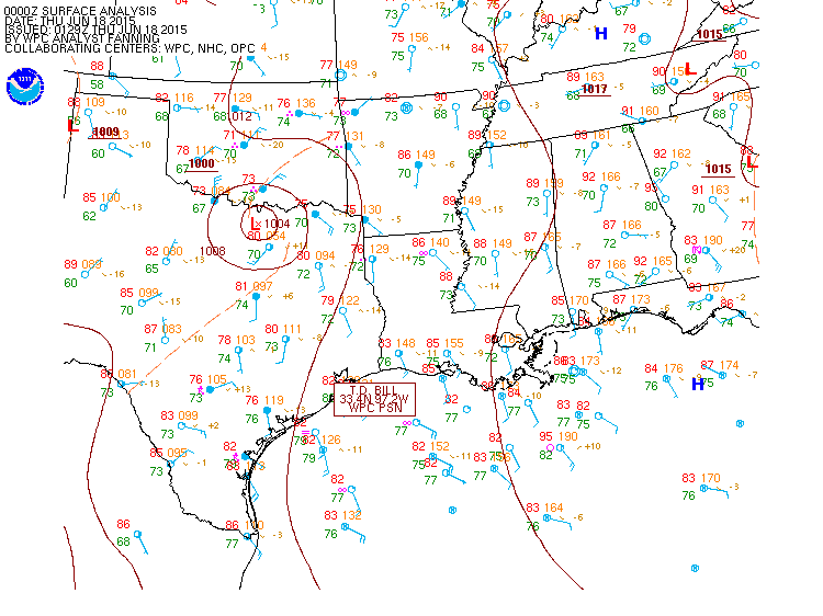
Latest Information (21z/00z – WPC)
- Maximum Winds: 25 kt/30 mph
- Minimum Pressure: 999 mb (pressure drop!)
- Center Location: 33.7N, 97.3W
- Movement around N at 10 mph
- More official information: http://www.wpc.ncep.noaa.gov/tropical/tropical_advisories.php?storm=BILL
- For local products including flood watches and warnings, please see the NWS at http://www.weather.gov
Flood advisories are still common place across much of eastern Texas and southern Oklahoma. Residents along the south Texas coast got extremely lucky that the extended rainband that exists currently over south Texas didn’t get there until this morning. Last night rainfall totals offshore were in excess of 20″.
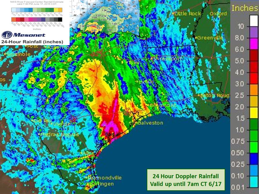
Rainfall totals. Sources:
-NWS: up until 12z 6/17
-OK Mesonet: Up until 00z 06/17
Rainfall continues across both states, and rivers are rising slowly but surely. Below you can see many of the TX/S OK gauges that are forecast or are currently in flood stage. Portions of the Trinity, Washita and Red Rivers are forecast to reach or are currently in major flood stage. This will make for at least a few days of rough travels over the bridges that parallel and cross these rivers. Since rain is still falling forecasts will have to be monitored for the next couple of days. Like the flooding at the end of May, it may take a few days or weeks for this water to wash down stream. Some of that water from May is still working its way toward the Gulf of Mexico. As Bill moves toward the Ohio River, current river flooding will be made worse. You can find current information here: http://water.weather.gov/ahps/

The Forecast:
Bill is essentially a rainstorm now with some gusty winds upward to 30 mph. The biggest threat remains heavy rainfall up to 6″ of additional rainfall from eastern Oklahoma to 3″ in northern Kentucky with locally higher amounts. The southern side of Bill may have some strong storms tonight into tomorrow morning with another 1-3″ of additional rainfall. Flooding is likely in northeastern Texas and eastern Oklahoma on Thursday. Minor intensification is possible, but unlikely as Bill moves into Oklahoma. Although the structure of Bill should remain well organized, the threat is highest in the rainfall department. WPC is forecasting this tropical depression to make it near the NW Arkansas border (10pm update…and across Missouri and all the way into northern Kentucky).

Average rainfall amounts through the next 72 hours
As I did last night, I have updated this post shortly after 10pm CT with the latest, this time from the Weather Prediction Center.
Stay safe!
–Jonathan
Share this!

Posted on Wednesday, June 17th, 2015, in Tropical Weather. Bookmark the permalink. Leave a comment.

Leave a comment
Comments 0