Daily Archives: Monday, August 24th, 2015
Invest 98L Now On The Radar After Danny Dissipates: Dry Air and Vertical Shear Too Much For Now
After lightning and thunder diverted hurricane hunters overnight, Danny gave up his fight to be tropically cyclonic this morning. Wind shear and dry air were too much to keep Danny’s thunderstorms vertically aligned during the post-sunrise hours. This appears to be keeping Danny at bay this evening while still bringing some of the islands much needed rainfall. Rainfall also falling in the in the far western Hawaiian Atolls along with a tropical storm force winds. Invest 98L, soon to be tropical storm Erika, is starting to develop characteristics of a tropical storm this evening. Hurricane Hunters head there tomorrow afternoon.

Ex-Hurricane Danny:
Chances are good that many of the islands will pick up upwards of 2″ of rainfall. Rain will likely taper off from east to west overnight starting in Guadeloupe and pick up in the Virgin Islands over the next few hours in an intermittent to scattered nature. Puerto Rico will likely see some shower activity during the early morning hours too. If Danny continues its trend of overnight thunderstorm flare ups, some could see stormy skies from St. Croix to Nevis. Chances of redevelopment are low, and impacts to the greater antilles will be limited to rainfall and breezy-at-times conditions.
Hawaiian Tropical Systems: Flooded Big Island
Although Kilo did not directly impact the island chain, it did kick start deep tropical moisture well to it’s east and north. Much of the big island was under a Flash Flood Warning this afternoon due to orographic lifting combining with that moisture. A flash flood watch remains in place for the rest of the afternoon and early evening (locally in HI) for more heavy rainfall. Honolulu had it’s wettest August day ever. Kilo itself is still a tropical depression a few hundred miles southwest of the islands being held away from Hawaii by high pressure. Intensification is anticipated throughout the week and Kilo is still expected to become a hurricane. Impacts remain to be rainfall due to deep southeasterly winds over the Hawaiian islands and winds up to tropical storm force on Johnston Atoll today and early tomorrow. Marine and aviation interests should be abreast of the latest information if they are expecting to be in the area SW of Hawaii over the next week.
Tropical Storm Loke should continue to intensify throughout the day and could bring hurricane conditions overnight in the far western atolls of Hawaii. By tomorrow evening Loke will move northwestward into the open Pacific.
Invest 98L…soon to be Tropical Storm Erika:
This invest will be one to watch over the next few days. Any uptick in convective activity over a sustained period will result in the formation of tropical storm Erika. Earlier ASCAT data showed that 98L was candy cane shaped with tropical storm force winds covering three-quarters of 98L’s circulation. Due to 98L’s fast forward speed it has struggled to maintain convection on the northern flank and westerly winds on the southern flank. Recent Windsat missed the western and much of the southern side of the system, which is where the trough of low pressure is likely open. Larger and faster systems have a harder time closing off due to the reversal of winds that is needed to close of the system. Winds on the southern side must blow against the mean flow to close of a tropical cyclone. A buoy near the center of circulation did not show west winds throughout the day, but has recently shown SSW winds getting to near tropical storm force. The windsat pass did show SW winds over a large region, although rain contaminated.
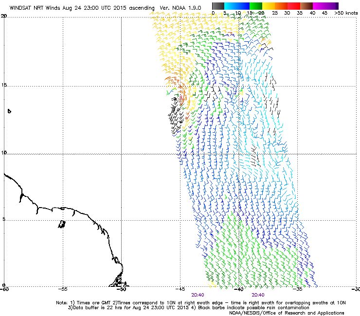
Windsat scatterometry pass this afternoon
Winds are estimated to be in the 40-45 mph range with a pressure around 1004 mb. Upon upgrade, Erika will be named without going through the tropical depression stage first. Intensification is possible over the next three days in a low shear environment and more moist air. Due to 98L’s larger size, it has been able to create an anticyclone aloft that has lessened wind shear near what will be a low level center. It seems that Danny was able to moisten the MDR all the way to the Caribbean, and thus this system may not have to deal with as much dry air.

Selected 18z Models through 96 hours
Much like Danny, future Erika will be guided toward the WNW by the Bermuda High, although at a slightly higher latitude. The exact trajectory that this system takes still has to be nailed down by future models, but there is a decent agreement in the current models of a slowly intensifying system approaching the islands in a few days. A weaker system will again be farther south. I have left off day five in the graphic above due to higher than normal uncertainty. Models have been playing with a late week trough that would drop into the southeastern United States, which would pick up this system. The trend – our friend – is for a weaker trough coming down. The results of this and the strength of the ridge remain to be seen.
Hurricane Hunters will be going out tomorrow and for much of the week to get a better idea of what is going on. It looks like more rain is on the way. Tropical storm watches may be needed soon for some of the islands.
Have a good night, stay prepared and safe!
–Jonathan, @JonathanBelles


You must be logged in to post a comment.