Daily Archives: Saturday, August 29th, 2015
Erika Remains A Flood Threat for Cuba and Florida; Invest 99L Threatens the Cape Verde Islands
As of 9:30 this morning, Tropical Storm Erika was officially declared an open trough of low pressure to the north of Cuba. As of 8pm, chances of redevelopment in the Florida Straights or Gulf of Mexico remain low. The vorticity or spin center remains over central Cuba. Ex-Erika is forecast to be near the Florida Keys tomorrow and within 100-150 miles for the Florida west coast Monday through Wednesday, close enough to bring heavy rainfall. Rainfall has already begun for most of southern and central Florida. 1-2″ has already fallen in a patchy fashion. Erika is not the only game in the Atlantic any more.

HEAVY, FLOODING RAINFALL is the biggest concern with Erika for Cuba and the Florida peninsula. For this reason, Governor Scott has declared a State of Emergency for the entire state of Florida. Satellite estimates continue to show diurnally driven rainfall for central and western Cuba totally a few inches. Portions of the Dominican Republic saw 6-9″ or 150-250 mm yesterday. Early rainfall estimates bring 3-6″ of rainfall to the Florida peninsula through the middle of the week. A flood watch begins Sunday morning and continues until later notice for the southern two-thirds of the Florida peninsula. There are still very soupy areas of the Nature Coast, SW Florida, and SE Florida from rains over the last two months. This additional rainfall could cause life threatening flash floods. Erika appears to be a multi-day event for Florida.
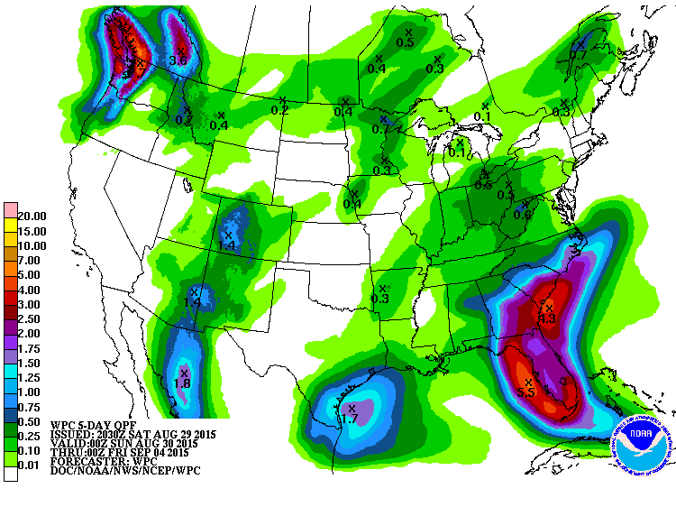
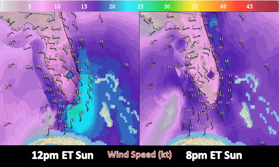
Winds will be gusty at times to 35-40 mph tonight near and in central and western Cuba. Winds will be highest over the Florida Keys on Sunday and Monday where gusts could be as high as gale force and in the Gulf of Mexico through Tuesday. Seas will be heightened, and any trips into the waters may want to be reconsidered. Overnight and into tomorrow, seas will be up to 12 feet in the Florida Straights and 10 feet in the central Bahamas. Winds will be higher closer to the Florida coast and in the Gulf starting Monday. There is a brief chance of intensification on Monday in the very warm Gulf temperatures, but chances of any strengthening will be limited.
From the National Weather Service
For now preparation and monitoring of this system is key. If you are in the flood watch or if you are near the coast, this should have your attention. Flooding is more likely in areas where they saw flooding earlier this month. Beach erosion is likely by this system as it moves by.
At least 20 people have lost their lives to flash flooding, and we are still waiting on numbers from the island of Hispaniola. Don’t add yourself to the list…be prepared for flooding.
Invest 99L
Farther east, much farther east, the NHC is watching a likely to-be-tropical cyclone off the coast of Africa. This system could be a tropical cyclone over the next day as it moves toward the Cape Verde Islands. Chances of formation are 80-90%. Heavy rain and gusty conditions are likely to begin tomorrow with a passage through the islands on Monday night and Tuesday morning. The next name on the list is “Fred.”
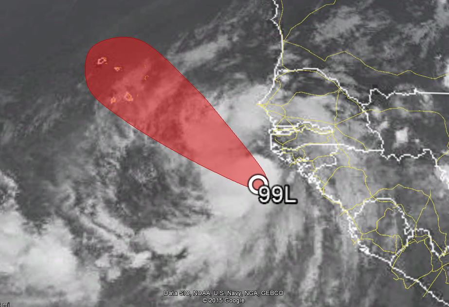
Models bring this system toward the west-northwest or northwest and into the open Atlantic following the Cape Verde Islands.
The Bottom Line:
If you’re in Florida, keep Erika in mind as it is still a moderate flood threat beginning tomorrow. We may also be looking at a few waterspouts over the next few days as well. This is a rainmaker, but it can still be deadly.
Stay safe, and stay out of the water!
–Jonathan, @JonathanBelles


You must be logged in to post a comment.