Tropics Show Signs of Life: Drought Relief?
It is August, and it appears that the Cape Verde season for tropical development has kicked into gear. A tropical wave has rolled past the Cape Verde Islands, and continues to move at about 15 mph toward the west still below 10°N latitude. Until today, most convection was rather shallow but organized. As we neared 00Z/8pm ET, convection boosted especially on the western side. The most recent passes of scatterometry/wind scans continue to show a well developed circulation, although surface analyses show there is an embedded tropical wave. NHC currently gives this system a 60% chance of development over the next 48 hours, however should convective trends continue those chances will climb quickly. This thought process is supplemented by a super majority of intensity models.

Precipitation Rate From Eumetsat. End of loop is 23:45z
New ASCAT scatterometer also shows that the western side at the surface is not as strong as it looks on satellite. The SW side of this system has no strong winds, but only small changes would make this classifiable as a tropical cyclone. Convection continues in that area. Winds are likely in the 25-30 kt range.
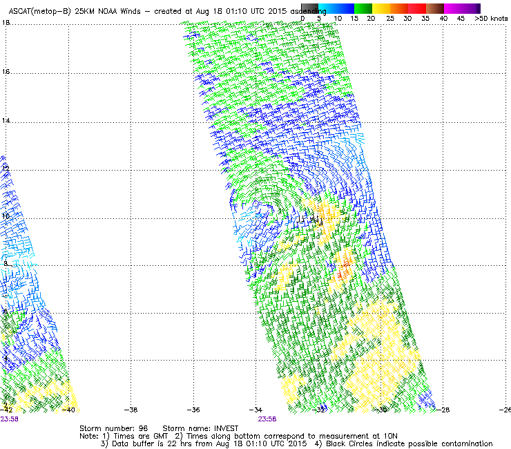
2356z ASCAT pass
96L continues to be embedded within easterly flow from the weak high pressure system to its north. Conditions are fairly favorable for the time being, and should continue to be over the next few days. Slightly above normal water temperatures, low shear and mid-level humidity above 60% should allow a slow, but steady development. The biggest hindrance to continued growth doesn’t really approach 96L until Friday or Saturday, and that is the large pool of dry air that the disturbance continues to fight well with. Even the over rambunctious HWRF brings drier air into the rainbands that will feed into the core by Saturday. The SHIPS model brings mid-level humidity down to below 40% by that time. Even with that dry air worked into the models, they seem to continue to intensify this system through Sunday, although at a slower rate following the interaction with dry air.

18z HWRF and Precipitable Water. Valid Saturday at 00Z
There is an upside to the tropics coming alive this year. In parts due to El Niño and the lack of tropical weather, most of the Caribbean has seen below-average rainfall for weeks on end. The forecast by the CPC, released on August 15th before 96L became a twinkle in anyone’s eye, continued that trend for at least a week for the majority of the Caribbean seen below in yellow in the underlying graphic. The Drought Monitor, released on the 13th, for Puerto Rico shows a long time issue of dry weather. The eastern half of the island is in severe to extreme drought. Much of Puerto Rico did see some rainfall from a disturbance over the weekend, but that dent was a small one. A weak tropical system would help.

Drought Monitor and Hazards Outlook released during the last week
Forecast Track and Intensity:
Current track models remain pretty well spread out, which means that they do not have the greatest handle on this system. Spread after 4 days remains at more than 4 degrees of latitude. I am not going to talk too much about impacts on land tonight, but I do want to stress that that uncertainty could mean the difference between the middle leewards and an open recurvature in the long term. There are a few things of note in the track models besides the uncertainty. Over the next 2-3 of days, we should see a continual motion toward the WNW as organization takes place. If faster than average intensification occurs, there could be a temporary turn toward the NW as 96L, or what would be Danny, takes advantage of a slightly deeper steering layer. [IF] enhanced intensification occurs, it would occur between Wednesday morning and Friday. SHIPS guidance currently puts the chances of that occurring at 47%. As the aforementioned drier air moves in, the disturbance would take a turn back toward the WNW or W as the steering layer thins and possible weakening begins. Most long range intensity models show weakening by the end of the weekend, which would take place before entering the Caribbean. Deep layer shear may also become a problem after that time. This weakening trend could be just in time for the Antilles to pick up some much needed rainfall.
I do want to mention again that both the intensity and track models have higher than average model error at this point in the development process. Recon is not scheduled at this point, but it is possible that flights could be on the schedule late this week or weekend.
00Z Model suite plus 18z GFDL/HWRF/AVNO
Bottom Line:
This will be something to watch over the next 7 days as it approaches the islands. There is a medium potential for both development and intensification by the end of the week. Based on the recent ascat pass, this formation time is likely within 24-36 hours assuming dry air stays out of the way.
As always, i’ll have more on twitter @JonathanBelles,
Also, let me know what you think of the new site layout.
–Jonathan
Share this!

Posted on Monday, August 17th, 2015, in Tropical Weather. Bookmark the permalink. 3 Comments.

Great analysis Jonathan. Muy detallado y sencillo. Sigue adelante!
LikeLike
Gracias!!
LikeLike
Reblogged this on the WeatherAction News Blog.
LikeLike