Wind Shear In Control in the Tropics: Danny and Kilo Likely With Different Outcomes
Danny has been struggling to keep its cloud canopy in place this evening as some models expected yesterday. Winds have been decreased to 65 mph as of 8pm. Winds of 40 mph or greater are possible should Danny hold itself together on the islands of Antigua, Barbuda, Montserrat, St. Kitts, Nevis, Anguilla, Saba, St. Eustatius, St Maarten, Guadeloupe, St. Barthelemy, and St. Martin. If you are on one of these islands, you may wish to skip down to the impact section below. Kilo on the other hand is expected to be close to the western Hawaiian islands in the middle of next week as a strong tropical storm or hurricane, but extensive uncertainty exists. I’ll break both storms down tonight.

Danny:
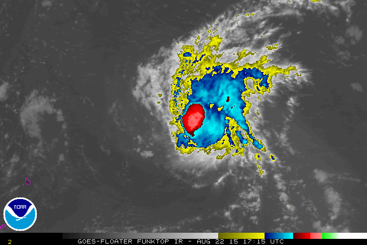
Current IR imagery and visible imagery from before sunset shows that the low level center is on the west or west-southwestern side of the current coldest cloud tops, although at times Danny has shown its low level center as a partially naked swirl. Tropical Storm Danny will likely be trying to reposition its center over the next few hours to a position under the former central dense overcast. That is the area where the warmest air resides and best convergence will be taking place. At the current state though, there is more air leaving the system through divergence aloft than entering the system. Warm/moist processes at the surface will have to try to keep up or Danny will evaporate. Danny seems to like the diurnal swings, so he may continue that pattern tonight and hold steady. Note also the very linear pattern of rainfall and convection below and on the satellite above. Radar imagery from the P3 were suggestive of two moderately strong linear bands, rather than the normal curved bands you would expect.
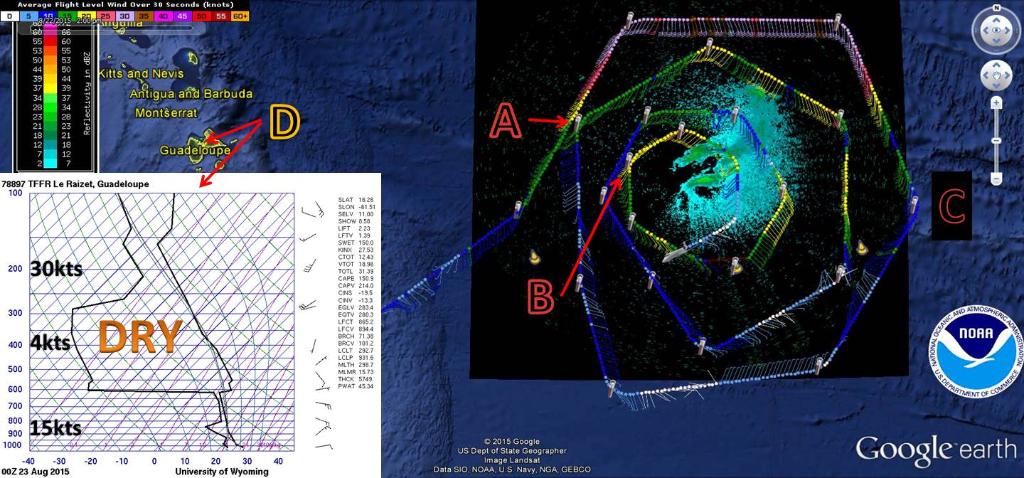
Today’s GIV flight and P3 2300z radar imagery (NOAA) and the 23/00z sounding from Guadaloupe (click to expand)
Gonzo’s upper level flight today continues to show a large difference between the western side and the eastern side of Danny. Below are three selected dropsondes from today’s IV flight with temperature (red), dew point (green), and wind (barbs, marked at noted levels). Dry air shows up very well ahead of Danny especially NW (pt A) and above 500 mb. At pt A, winds also increase up to 200 mb. Mid-level speed shear is around 20 knots in the northwestern dropsondes (pts A and B) with shear out of the SSW to SW at 850-200 mb. Close to Danny’s core, deep layer shear is around 30 kts, but some of that higher low level wind could be respective of Danny. The eastern dropsonde – pt C – shows a more consistent wind pattern with height.
Tonight’s 00z sounding from Guadeloupe gives a very dry picture above 600 mb. High level winds of 30 knots are similar to what the GIV found early in it’s flight. Shear (850-200mb) of about 15 kts out of the SW/SSW exists at that site currently.

From NOAA Hurricane Hunters
HWRF and GFS continue to suggest that persistent, but persistently shear convection is likely to remain with Danny over the next few days. SST’s are anticipated to increase by more than a degree and a half Celsius over the next 3-5 days by the SHIPS model. Shear is expected to remain moderate, and dry air is only expected to increase by 5-15% by day 5…much too late for any resiliency.
The Forecast:
The 00z models continue to agree that the weakening of Danny through 48-72 hours, but beyond that the statistical and dynamical models diverge. The statistical models continue to show an increase in wind speed by the middle of next week, but this seems unlikely due to the dry air and shear that is expected. At this point, this just seems like an alternative to a more likely forecast. Danny is likely to continue to weaken through at least four days. The biggest batch of dry air currently being seen in Guadalupe will push west into the central Caribbean, but that doesn’t mean that Danny won’t catch some of it. Chances of dissipation are also nonzero due to the strong shear and Danny’s small size. If dissipation were to occur, it looks most likely as Danny approaches Puerto Rico and the Dominican Republic on Tuesday. By mid week, Danny may level off over very warm SST’s and perhaps slightly more moist air. Beyond that point, oceanic conditions improve and marginally conducive atmospheric conditions may exist again. Short-term intensification is possible, but at this time unlikely.

00z Track Models from Tropical Tidbits
On Thursday, as Danny is passing through the southern or central Bahamas, an early season mid-latitude trough will dig into the eastern Gulf of Mexico and southeastern US. This may shield the United States from an impact, but considerable uncertainty exists in this turn. The Canadian and GFDL are strongest with this trough while the GFS is weakest as of 18z. The NHC and WPC solutions are farther south and west in their most recent forecasts.
Danny’s Impacts:
The biggest impact will be rainfall, but that is only in comparison to the other impacts. With Danny being sheared from the southwest, most of its thunderstorm activity will be located to the NE of its center and will place the islands on the dry side. That being said, 1-3″ or 25-75 mm is possible from Antigua and Barbuda to Puerto Rico with higher amounts in the mountainous areas. A secondary concern for the islands mentioned at the beginning of the post is winds greater than 40 mph. These winds will be confined within a 50-60 mile area mainly to the northeast of the center of circulation. Again, these will be mainly over the ocean. The highest probabilities of those winds currently exist for Barbuda, Saint Martin, and Anguilla.
Tropical Depression Kilo:
Kilo has struggled to remain a tropical cyclone over the last day or so with strong shear keeping clouds away from the center. Kilo now appears to be undergoing the process of re-centering, which is common in weak tropical storms. Cloud tops are very cold and with new convection firing consistently, intensification is likely sooner or later
Models this far have been something like a spider squashed in the general northwestern and then northern direction over the next five days. This may be due to an overall complex synoptic pattern and a lack of observations, but with twice a day hurricane hunter flights upcoming that second hindrance should be lessened. Water to depth temperatures are expected to increase and shear is anticipated to drop off a bit. This combination should allow Kilo to intensify gradually over the next few days. CPHC shows this:

Farther west, Loke had a similar fate to the other two cyclones being watched. Drier air has weakened Loke into a tropical depression, but it is anticipated to flirt with the Date Line as it moves northward. Modest intensification is probable due to weak shear and high sea surface temperatures. At the end of the upcoming week Loke is forecast to come into contact with ex-Atsani from the west Pacific and get sucked in.
Possible Future Tropical Activity in the Atlantic:
The National Hurricane Center is currently watching three possible future disturbances in the basin including invest 97L and two tropical waves. The models have been pretty frequently showing that the next wave, currently SW of the Cape Verde Islands, as the next tropical cyclone in a few days. As of 00z, that tropical wave is now invest 98L. For those of you in the Caribbean watching your rain chances deteriorate, this may be your next chance. The current zone of development follows a similar track to Danny, although motion will be considerably faster. Low latitude dry air and shear above 15N will slow down that wave’s development, but the NHC has given it a 60% chance of development. Early models for 98L show a track just north of where Danny tracked, but these will have large tweaks in the days to come. Invest 97L on the other hand is currently falling apart. The third disturbance will have to deal with some shear as well, but it’s too soon to know how much.

Stay tuned, stay safe, and stay prepared!
–Jonathan Belles, @JonathanBelles
Share this!

Posted on Saturday, August 22nd, 2015, in Tropical Weather and tagged 97L, 98L, Atlantic, Bahamas, CPHC, Danny, Hispaniola, Kilo, Loke, NHC, Pacific, Puerto Rico. Bookmark the permalink. Leave a comment.

Leave a comment
Comments 0