Tropical Storm Erika to Face Land Interaction on Friday with Long Term Repercussions for Florida, Bahamas
Front and Center: Puerto Rico, the Bahamas, and Florida. Also in the future: Flooding. It is finally starting to clear out in Dominica after a day of rainfall totaling more than 12″. At least 4 have lost their lives due to freshwater flooding on that island. Heavy rain continues for northern parts of the Leeward Islands. This system is slow to let the islands dry out. Flooding rainfall remains a moderate threat for the Virgin Islands and for Puerto Rico. So far rain has been light in the US Territories.

Visible imagery ending 6:15pm AST
Tropical Storm Erika weakened as expected this morning and afternoon, exposing a low level center to the northwest. Winds are currently 45 mph and forward speed has slowed down just a tad. Against the odds, Erika has shown signs of enhanced convective activity in a curved band fashion. Overshooting tops became apparent following the 5PM ET hour near the old low level center and in the southern quadrant. Afternoon microwave imagery showed that Erika had a decently strong convective band to the right, and visible imagery has improved since then.

Marigot Airport in Dominica/@AlisonteleSUR on Twitter
Current mid and upper-layer wind shear should continue to push Erika’s thunderstorm activity off toward the east and southeast…and toward the central Leewards. Late this afternoon, convection was kick started and seemed to take the shape of a well formed tropical storm again. Shear may have even abating just a smidge according to CIMSS charts. Divergence has increased aloft and an outflow channel may be forming to the north and south. Presumably, another diurnal uptick in activity is beginning.
Current surface analysis shows a 1019 mb Bermuda high in between Bermuda and Erika heading northwest. A stationary front and trough lurks over northern Florida, southeast Georgia and the western Atlantic. The high pressure system will guide Erika toward the west or west-northwest over the next couple of days with a turn to the right soon after as the ridge slows down. The NOAA G-IV is currently in flight getting a good idea of the synoptic pattern surrounding Erika.
Surface recon has shown that there may be a large, multivortex surface center. This is not out of the ordinary, but does slow down the organization process. The mid level center seems considerably stronger, possibly up to strong tropical storm force. Recent gusts on St Croix are near 62 mph, which could be due to a strong rain band associated with one of the small vortexes. There is a small convective plume on radar in that location, but it is a secondary temperature minimum at cloud top level. The most recent center fix has a center close to this location without many measurements to the south.
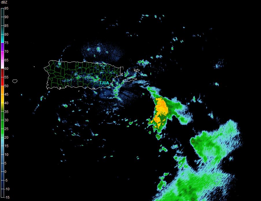
0054z Radar with an apparent mid-level center/Gibson Ridge
Forecast Impacts:
It has been very clear over the last 24 hours that rainfall is by and large the biggest threat with Erika for the short term. 6-12″ has already fallen on some of the islands where it rained most of the day. Considerable rainfall threat exists tonight for the US Territories.

Current Forecast from NWS San Juan
Tropical storm conditions are probable in waves:
- Rainfall: 4-8″ or 100-200 mm of rain is forecast to fall overnight from the British Virgin Islands to Puerto Rico overnight tonight with isolated amounts to 12″ or 300 mm. Starting after midnight tonight and going through late tomorrow afternoon, portions of the Dominican Republic and Haiti could see 4-8″ or 100-200 mm of rain. Rain will continue on to the southern Bahamas on Saturday. Flash floods are probable.
- Winds: Areas in the tropical storm warning should expect winds of 40 mph or greater during the overnight hours tonight and tomorrow as far west as the Haitian Border. These winds could knock over weak structures or flooded trees.
- Storm surge and tornado threats remain low. Seas will be elevated around the US Territories for the next day or so.
The Forecast:
Before I can talk about the road ahead, I have to talk about what happened last night. As we passed the three o’clock hour last night, it became apparent that Erika was diving to the south or left of the forecast track. Thunderstorms expanded a bit south and west as well. You can see this dip south below. The ramifications of this left turn could be felt throughout the future track. Following the turn, the NHC has made two leftward nudges to its track and pushed it closer to Hispaniola. Depending on how close to that island this system goes, it could further disturb Erika’s circulatory system. This would lead to a weaker system and would tend to push a track farther west. The 8pm Advisory does have a westward motion once again.

That is only one possibility. A second possibility is that intensification occurs over the next day or so, which would tend to lean toward a more east or right track. The outcome of a hit or mess is now the next checkpoint this system’s legacy. Don’t forget that wind shear is also in play here. Thunderstorms remain to the south and east of the low level center, and this will hinder development over the next day or two. Outflow to the north, east, and south continue to suggest this system will blossom overnight until Puerto Rico or the Dominican Republic get in the way. Erika will have to take on heck of a right turn to miss Hispaniola altogether. If you look at the models below, you will see a straight line marked XTRP, a line I would normally remove. This go around I left that line on because it illustrates the movement this afternoon, and the need for a right turn in order to validate any model. Even if that turn were to occur, the end of the model suite has a 600-700 mile spread. That’s a very low confidence forecast.
Either possibility will include daily swings in intensity and thunderstorm activity.

1800z Track Models plus extrapolation
Following that hurdle, the road looks nearly clear for Erika to intensify. Water temperatures will continue to climb in the Bahamas or Florida Straights over the Gulf Stream. Shear is expected to lessen, and forward speed may temporarily slow down. Intensification is nearly a sure bet as long as Erika’s structure remains somewhat in one piece. We’ll have a good idea how many pieces we will have to pick up late tomorrow evening.

00z Intensity Models/Tropical Tidbits
If Erika can make it make into the Atlantic waters with any sort of structure, the intensity forecast gets a little easier. In fact, intensity models seem to be consolidating on a solution. Water temperatures in the mid to upper 90s and a favorable atmospheric environment would surely lead to intensification. That’s the easy part. The hard part? How much does it intensify. It is likely that both hurricane models (in pink and purple above) are wrong and that the outcome is somewhere in the middle. We’ll discuss that in the days to come. Current consensus models bring Erika to hurricane intensity by Sunday or Monday. Landfall on US soil is a possibility beyond Sunday evening.
It is time to prepare NOW:
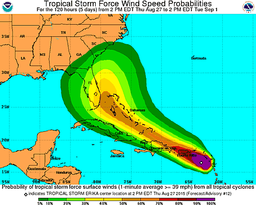
Florida’s emergency management agency has moved into a partial activation, and many local and county governments may activate this weekend in Florida. If you are in the tropical storm watch or warning areas farther southeast…you should be preparing now. Due to the lower than normal amount of certainty with this system, it is urged that residents of the Florida peninsula at least begin to think about a hurricane plan and their storm kits tonight and tomorrow with action coming by the end of the work week. The bread and milk index on this system is about a 5 out of 10 for southeast and east central Florida. Rain chances will be elevated through Saturday as the stationary front lurks across the Nature and First coasts. Beyond that point the forecast will highly depend on Erika’s path. We’ll talk about Florida impacts in the nights to come, but below is the NHC’s preliminary chances for tropical storm force winds in the next five days. Note that chances of wind speeds above 40 mph will likely top 50% tomorrow in Florida. If you are anywhere in the >5% chance range below, you should have an action plan ready to go.
Get prepared, stay safe, and maybe learn a little over the next couple of days. Prayers for everyone in Dominica and Guadeloupe.
–Jonathan, @JonathanBelles
Share this!

Posted on Thursday, August 27th, 2015, in Florida Weather, Tropical Weather and tagged Bahamas, Dominica, Dominican Republic, Erika, Florida, Gulf of Mexico, Hurricane, Puerto Rico, Tropical Storm, Virgin Islands. Bookmark the permalink. Leave a comment.

Leave a comment
Comments 0