Watching the Heartbeat Monitor on Tropical Storm Danny as it Approaches Dominica and Guadeloupe. Hawaiian Threats Lessened, but Tropical Storm Warnings Hoisted
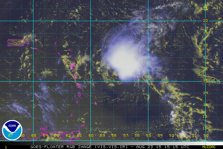
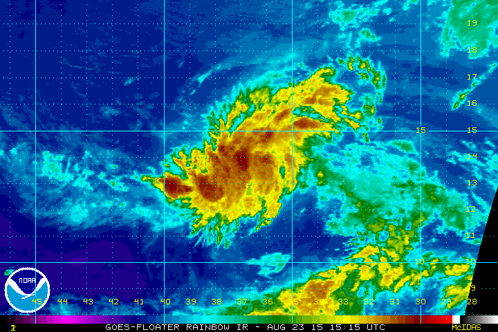
Tropical storm Danny’s day has not been a good one. It woke up with the fan on high and some extra dry, crusty surroundings. All it wanted was a Caribbean vacation, BUT the hurricane hunters had a difficult time finding a closed low level circulation this afternoon. As recent as this morning, Danny had a fairly robust mid level circulation with a decoupled, but somewhat active low-level circulation to the southwest. You can easily see the low level swirl, in yellow, ride out ahead of the weakening convective plume to the northeast, in white. As the sun goes down, the hours on Danny’s track may be short. 98L has a long road ahead of it as it speeds across the Atlantic. Tropical depression Kilo is now forecast to stay away from the Hawaiian islands.
Tropical Storm Danny:
Guadeloupe radar and radar from the afternoon P3 flight show a pretty inactive scene. Just a few showers dot the western Atlantic, but I suppose any rain in some of these places is better than no rain. It is also noteworthy that most Danny’s shower activity is off to the northeast. A strong, somewhat curved band exists well to the NNE of the likely center, which as of 0000z is 140 miles east of Dominica. Convection is also blossoming in the northwestern quadrant since 0000z on infrared imagery. Rainfall is likely to become intermittent from Martinique northward over the next few hours. The heaviest rain is likely Guadeloupe northward during the overnight and early morning hours.
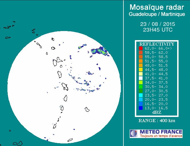
Guadeloupe Radar at 2345z
The Air Force Hurricane Hunters have located a weak low level center of circulation this evening with a pressure of 1008 mb. Winds of only 35 mph were found, and it is likely that Danny will be downgraded tonight unless Danny reacts to diurnal conditions. Danny will likely pass between near or just north of Dominica overnight. A tropical storm warning continues for Antigua, Barbuda, Montserrat, St. Kitts, and Nevis. A tropical storm watch continues for the USVI and Puerto Rico. These may be dropped if Danny weakens any more. Gusty winds are possible on mountain tops. A couple of inches is possible in the heaviest rainfall locations in the northern Leewards and US territories tonight and tomorrow with higher amounts in the higher terrain.
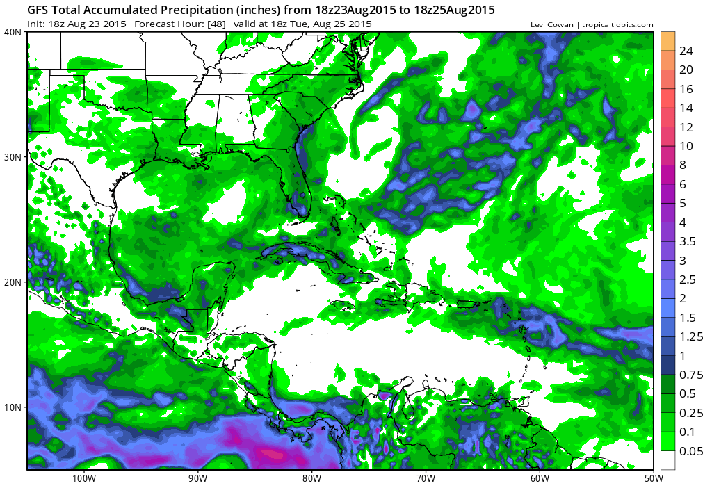
18z GFS Accumulated Rainfall through 48 hours
According to the CIMSS latest shear charts, shear has come down to below 20 kts, but that may be too little too late. Without a low level center to collect moisture and heat in the inflow layer, generally below 3000 ft, chances of returning to a growth phase or regeneration phase will be difficult especially with the lackluster environmental conditions. The 00z Guadeloupe sounding shows full depth shear of 10 knots at roughly 200 degrees/WSW, also with a little bit more moisture.
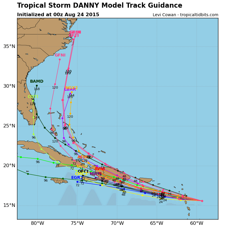
Weakening is anticipated to continue as it gets into the eastern Caribbean tomorrow. Rainfall will be the biggest blessing/threat for most. The sea breeze and orographically enhanced rainfall that most islands see on a daily basis during the summer may do more damage than Danny will. Danny’s spaghetti plots have slid down to the south of the Greater Antilles due to recent movement and a weaker system than forecast. The 00z models compared to 18z are a little more spread out over Hispaniola, but by that time it doesn’t seem to matter because dissipation is likely by then.
From Tropical Tidbits
Invest 98L
This tropical low is speeding across the Atlantic at 20 mph or so, about twice as fast as Danny’s trek across the same span of the mean development region. 98L, or what will likely become “Erika” by the middle of this week, is at a slightly higher altitude than Danny and conditions are expected to be similar to or worse than what Danny is experiencing now when it gets across the Atlantic. It’s forward speed will also be an issue at some point, but right now it does not seem to be a problem. The NHC currently gives this system a high chance of development, but does note the bad conditions at the end of the week.
The current forecast for this system is very similar to Danny, without the hurricane status. 98L should be somewhere north of the Caribbean by the end of the week potentially still as a tropical storm.
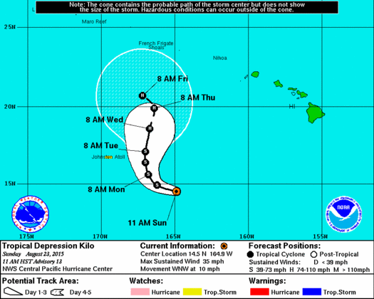
Kilo and Loke:
The early part of the forecast remains similar to in days past, but the Central Pacific Hurricane Center changed the end of the forecast drastically for yesterday. Notice that by the end of the week, the track now turns to the northwest rather than the northeast. This is in part due to steering from high pressure to the east and then an area of weaker steering during the middle of the week. A tropical storm watch is in effect for Johnston Atoll. Kilo is expected to strengthen on the western side of ridge as it passes Johnston Atoll on Monday and Tuesday.
A tropical storm watch is also in effect for Midway island and parts of the eastern Papahanaumokuakea Marine National Monument, but this time due to now tropical storm Loke. A tropical storm warning is in effect for the central Papahanaumokuakea Marine National Monument. Loke has the opportunity for some intensification as it approaches the atolls. Loke is a rather small system with tropical storm force winds only extending out 35 miles from the center. Rough surf and some heavy rain will approach the atolls early tomorrow with the worst conditions expected overnight Monday into Tuesday.
Final Remarks:
Overall, landfall impacts are lessened from these storms. The good news is that rainfall is still in the cards for many of the Caribbean islands, but there still may be a small threat for landslides and trees down due to gusty winds and excessive runoff on very dry grounds.
Stay safe, stay prepared, and have a good night!
–Jonathan, @JonathanBelles
Share this!

Posted on Sunday, August 23rd, 2015, in Tropical Weather and tagged 98L, Caribbean, Danny, Hawaii, Hispaniola, Kilo, lesser antilles, Loke, Midway, Puerto Rico, Tropics. Bookmark the permalink. Leave a comment.

Leave a comment
Comments 0