Daily Archives: Saturday, May 26th, 2012
Subtropical Storm Beryl to make Landfall Tomorrow Night
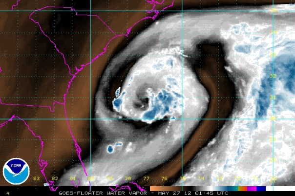
Subtropical storm Beryl is slowly moving toward the southeastern US coastline this evening. The Hurricane Hunters were out inside of the storm earlier today and determined that winds were slightly stronger than reported yesterday and since then winds have remained the same. The switch over from subtropical to tropical classification is well underway, but seems to have been slowed midday by dry air engulfed into Beryl’s core, where it still remains. A look at water vapor below shows dry air still entrenched in the middle of Beryl’s center of circulation, seen in black. Drier air outside of Beryl is in brown with stronger storms in blue and white:
The latest advisory from the National Hurricane Center is as such:
- Winds: 50 mph
- Minimum central pressure: 998 millibars
- Location: 30.8N 77.2W
- Movement: SW at 7 mph
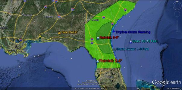
- Current Tropical Storm Warnings: Volusia/Brevard County Line, FL to Edisto Beach, SC (seen in blue on the impact map)
The Forecast:
Beryl is currently following clockwise upper level flow around an area of intensifying high pressure to the northwest, which is expected to build in to the north and east of Beryl for about the next 36-48 hours. Beryl should move inland somewhere between St. Augustine, FL and Brunswick, GA, but it is important to note that rainfall and high surf and surge are possible well beyond this area and well inland. See the impact section below for this information. After that time a weakness will develop as Beryl gets stuck over northeastern Florida or southern Georgia. As this weakness opens, Beryl will follow it to the northeast and out over the coastal Carolinas fairly rapidly.
I believe that the currently entrenched dry air should work its way out and convection should begin to burst over her center, which will allow for a transition to tropical classification. Combined with this and placement over a relatively low shear environment and the warm sea surface temperatures, I think that modest intensification is possible during the next 12-24 hours. Another reconnaissance plane will investigate Beryl tomorrow morning primarily to get a status on the conversion to completely warm core, but I think at about this time intensification may begin. I’ll be watching this flight closely.
The Impacts:
- In the area outlined above as being in a tropical storm warning, winds of greater than 40 mph are possible along the coastline and up to 30 miles inland
- Seas will be up from the Bahamas to North Carolina over the next day or so as Beryl moves inland, on the order of 10-15 feet nearest the landfall zone; Boating is not advised
- Beaches will be closed in Georgia and Florida, so check ahead with local officials to make plans, but in general the best rule of thumb is to stay away from the shoreline through at least Tuesday
- Very heavy rainfall is possible nearest the landfall area, and isolated amounts of up to 8-10″ are possible. This should put a measurable dent in the drought that is in place across southern Georgia and northern Florida
- One favorable impact of Beryl is that it will temporarily break the heat wave across parts of the southeast when its cloud shield moves in tomorrow afternoon. Tallahassee broke its record high today, hitting 100F, but that location as well as locations across north Florida should remain in the 80s and lower 90s through the Memorial Day weekend
Looking ahead:
I will take a look at your memorial day forecast tomorrow afternoon as well as final landfall forecasts. Short term observations and forecasts can be found on my twitter @JonathanBelles
Special Look at Storm Chasing in the Plains:
This summer, one of my friends and co-graduates at Florida State University is in the Great Plains storm chasing and doing research with Josh Wurman and the Discovery Channel “Storm Chasers” crew. Last night she was hit (literally) by one of the worlds most beautiful and terrifying natural phenomena at the same time, a tornado that crossed her path and destroyed a Kansas house. On the porch before the tornado struck was an elderly woman, who Amanda was on scene to help minutes after destruction. Amazingly well written, and I think it’s truly one of the best POVs from a storm chaser and the best description as to why they are out there…to save lives. Read this story about how Amanda and Pat, and how both their lives changed in an instant. Thank you Amanda for sharing this!!
http://livinthedreamtornadochasin.blogspot.com/2012/05/humbling-night.html
Have a good night, and stay safe!!


You must be logged in to post a comment.