Emily Regenerates
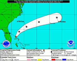
It took a couple of days for Emily to recover from the mountains of Hispaniola, but she is as of 5pm a tropical depression once again. Recon went around in the thunderstorms this afternoon looking for the remnants of Emily had found a very messy circulation center near Grand Bahama island and a few other lesser defined vortices. She tightened up during the early afternoon and may have had winds of 40 mph at one point. Her thunderstorms are now less impressive. She is moving away from the northern Bahamas towards the north. Today she dropped numerous inches of rain in the northern Bahamas and in southern Florida on the western side of Emily’s circulation. Below is Emily’s current information from the NHC and the current satellite image, which is linked to the current satellite loop:
- Maximum sustained winds: 35 mph
- Minimum central pressure: 1011 mb
- Movement: due north
- Location: north of Grand Bahama island or 24.7N 28.2W
Posted on Saturday, August 6th, 2011, in Tropical Weather and tagged Bahamas, Emily, Tropics. Bookmark the permalink. Leave a comment.


Leave a comment
Comments 0