A Reminder…The Season is Coming
Good afternoon storm watchers!
The NHC is getting an early surge of activity today with areas of low pressure in each tropical basin that have been designated as areas of “invest”igation. In fact, the eastern Pacific may get their first storm just in time for the beginning of that basin’s hurricane season, which runs from May 15th through November 30th. The NHC has given this area a 40% chance of tropical development within 48 hours.
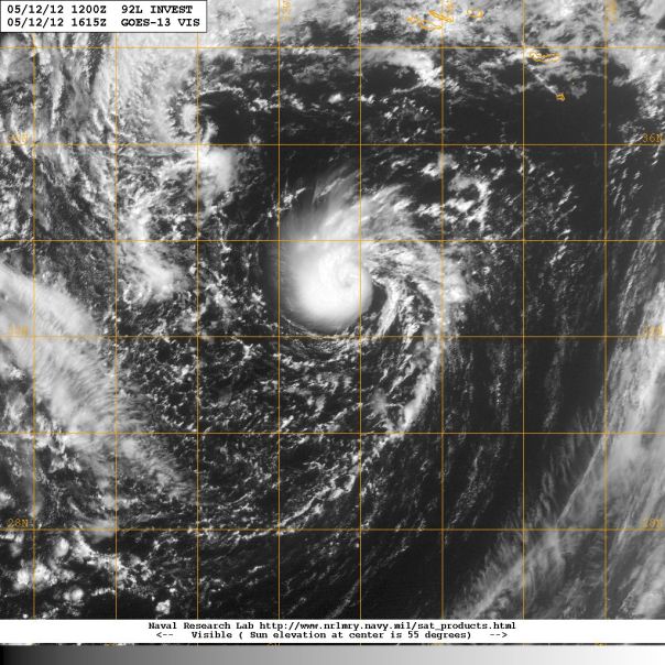
Generally on this adventure, I will tend to focus on the Atlantic side of the tropics, as well of course as Florida weather. The third invest of the year was designated earlier this morning, and the designation was given to a 1009mb low in the far eastern Atlantic just south of the Azores pictured below:
Based on satellite estimates, Invest 92L has winds of 35 mph with higher gusts. This low pressure system is causing waves on the order of 15-17 feet around that area, which may cause some beach erosion in the Azores. What is interesting with this system is its structure. Generally, tropical low pressure systems of this intensity are not shaped like a comma, which is more characteristic of a tropical storm. The computer models don’t seem too impressed with this area, but I believe it is wrapping up quite nicely with good banding structure and good outflow around all sides of the system. If this trend continues, I’ll be on the lookout for a special tropical weather outlook from the NHC. Any real bump in wind speed would technically make this a tropical storm given that this system is warm cored. Based on cyclone phase diagrams run by the GFS, 92L is not currently warm core, but is expected to be on Monday.
As always, this system may not become a tropical cyclone, but now is always the best time to get prepared for hurricane season. Don’t forget to put valuable documents and pictures in water proof containers in an easy spot to grab in case you have to leave your house for a natural disaster.
Update (1:50pm ET): The NHC has indeed issued a special TWO, and have given 92L a 40% chance of tropical or subtropical development over the next 48 hours. This is no threat to the USA.
Posted on Saturday, May 12th, 2012, in Tropical Weather and tagged Hurricane Season, low pressure. Bookmark the permalink. Leave a comment.


Leave a comment
Comments 0